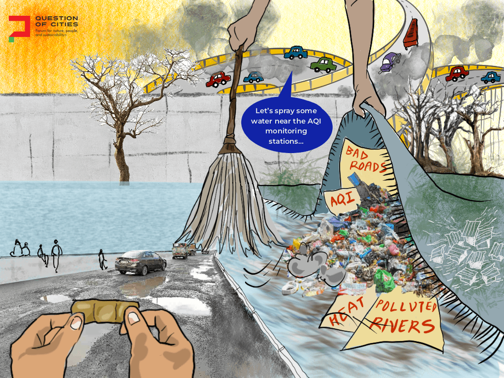

Cities in India can no longer afford to ignore climate change or push such considerations to the periphery. Indeed, climate adaptation has become central to urban planning and policies. Yet, urban planning remains fragmented, with a motley and varied array of government agencies managing interconnected portfolios such as transport and housing, sewage and lakes, pollution and parks in silos and without the necessary conversations.
Thus, we see reactive rather than proactive planning – cities widen drains after floods, install pumps after waterlogging, and plant trees after heat waves. These actions are without a systemic approach, focused on easy technofixes that provide short-term political and economic benefits, with limited possibilities for the deep structural change needed to reduce climate vulnerability.
This reveals a deeper problem. The challenge facing India’s cities is not only climatic but institutional. Cities remain trapped in the “rat race” of urbanisation in which governments, developers, planners, and engineers pursue locally rational goals without questioning the broader logic shaping urban growth. Climate adaptation, therefore, risks becoming another form of crisis management rather than a transformative rethinking of urban life.
The framework of the three loops of learning explains why this pattern persists. The first loop focuses on improving existing systems through technical efficiency. The second loop questions the institutional rules and planning assumptions producing vulnerability. The third loop rethinks how decisions are made and promotes forms of governance that can learn and adapt over time.
When read through this framework, Indian cities reveal the possibility of reshaping city-making itself. Using examples of Bengaluru, Chennai and Delhi – located in diverse geographies, exposed to different climatic and ecological risks – we illustrate the application of the three loops of learning to show how climate-resilient urban planning in India will need us to rethink, fundamentally, the relationship between our cities and the long-neglected ecosystems that support and nourish them.
Bengaluru: Floods and the limits of first-loop adaptation
Bengaluru lies on a plateau, divided into two watersheds, a semi-arid inland city in the rain shadow of the Western Ghats without access to any natural perennial sources of water. It originally depended on an interconnected network of lakes (human-created irrigation tanks) along a topographic gradient for its water supply. In 2022, Bengaluru experienced severe floods that brought the city to a halt for several days, flooding the city’s Outer Ring Road corridor, luxury apartments and gated communities, and leading industrial and IT parks.
This exposed the ecological contradictions in Bengaluru’s growth model, where much of the city’s new business and residential areas in Marathahalli, Whitefield and Sarjapur have been built on the lakes, wetlands and interconnecting channels surrounding Bellandur and Varthur, the city’s largest lakes, leaving no outlet for the rainwater. The response from authorities followed a familiar pattern – cleaning stormwater drains, dealing with encroachments along ‘rajakaluves,’ and proposing the widening of drainage channels.
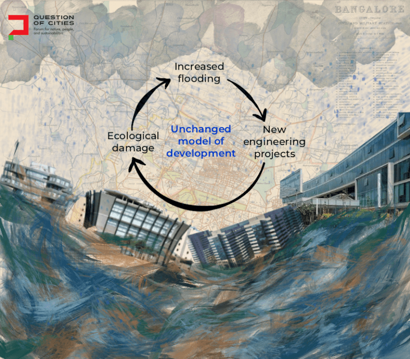
These measures aimed to improve existing systems. They did not question the pattern of urbanisation that had helped create the crisis. The city now faces a repeating cycle. Ecological damage increases flood risk and floods trigger new engineering projects. The model of development that created this problem largely remains unquestioned or unchanged. To deploy second loop learning, Bengaluru must focus on the rules and assumptions that shape its development.
At the start, the city must go beyond its limited focus of upgrading drains and incorporate a watershed approach, recognising not just lakes as critical but also wetlands and interconnected kaluves or drainage networks, which need to be restored and rebuilt to enable groundwater infiltration (ensuring that the watershed acts as a sponge to soak up the rainfall) as well as to enable water to move from one lake to another along an elevation gradient, instead of flooding the local neighbourhood.
Strict hydrological assessments must be implemented for new development projects, and existing zoning laws rightened and enforced. Infrastructure projects must be subjected to mandatory hydrological review. This also calls for, as activists and experts have long demanded, better coordination between state agencies and parastatals including the Greater Bengaluru Authority, Bangalore Development Authority, Bengaluru Water Supply and Sewage Board, and the Karnataka State Pollution Control Board that rarely coordinate and often act at cross-purposes.
In addition, urban planning must recognise the deep connection between social and ecological risk. Informal settlements are often located in low-lying areas where residents face greater risk and have few resources to recover. This was clear in the Bengaluru floods of 2022, where wealthier neighbourhoods received greater media coverage and quicker State support, while poor migrant communities were left to flounder on their own.
The third loop response would go beyond technical fixes and institutional reforms focusing on how decisions are made. Adaptive co-management, rather than experts-led planning, offers a way forward by bringing together governments, scientists, civil society groups and local communities. It creates a system that can learn from experience and respond to changing conditions – including citizen-led lake stewardship networks, participatory floods mapping, and neighbourhood watershed councils to create iterative adaptive planning systems with ecological feedback.
Chennai: Learning from water
In a different context, Chennai demonstrates the impact of ruthless construction on the floodplains, marshes, and mangroves that buffered the city from coastal flooding. The 2015 floods were severe because of the loss of wetlands such as the Pallikaranai Marsh, other lakes, and surrounding marshy areas which decimated the city’s natural capacity to absorb flood waters. At the same time, Chennai frequently battles drought. In 2019, the city’s reservoirs ran low, and ground water supplies were scarce.
Chennai’s experiences with flooding and drought are two sides of the same coin, emanating from the structural problem that plagues Indian urban planning – namely a loss of imagination and understanding of ecology as central to the functioning of the city as a metabolic system.
Much of Chennai’s climate response reflects the first loop learning – investments in more concrete seawalls, upgrading drainage canals, and the like instead of restoring the ecosystems or examining the ingrained faulty processes of land-use planning (driven by political economy) that caused the problems. But Chennai shows that cities can learn from past crises. In 2003, after years of water shortage and falling groundwater levels, the Tamil Nadu government made rainwater harvesting mandatory for buildings across the city.
This represented a significant second loop shift, moving beyond emergency water supply responses to restructuring the relationship between buildings, groundwater and urban governance, embedding the concept of recharge into the logic of urban development. Groundwater levels improved in several parts and rainwater harvesting became normalised. Yet, it continued to have limitations. There was no understanding that rainwater harvesting in individual buildings needed to be linked systemically with groundwater recharging by protecting and restoring the interconnected network of lakes, wetlands and mangroves.
This would require an additional second loop response: integrating lakes and wetlands into master plans, going beyond piece-meal approval of construction projects to understanding the impact of real estate zoning on the watersheds, and mandating climate risk assessments and banning construction and infrastructure along the city’s exposed coastline. Coastal cities cannot be governed through rigid engineering alone, because coastlines, tides, rainfall systems are inherently dynamic. Fixed or static planning models often struggle to respond to these changes. Cities need planning systems that can learn from new information and adjust over time.
This is where the third loop adaptive co-management becomes essential to address inequity. Fishing communities, informal settlements, and low-income neighbourhoods near waterways experience the highest flood risks while having the least influence over planning decisions. This could include partnership with fishing communities, collaborative wetland monitoring and floodplain management, by residents and technical experts, integrating local place-based knowledge with engineering approaches, and building climate resilience via democratic participation.
Delhi: Heat, mobility and climate inequality
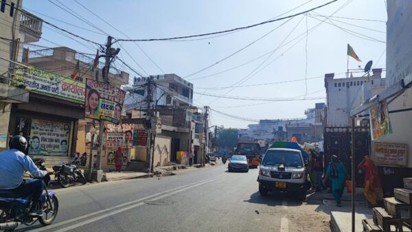
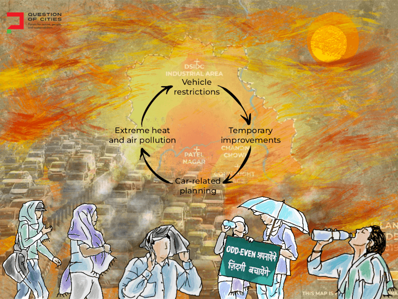
Recent heat waves have pushed temperatures above 45 degrees Celsius across northern India. In Delhi, extreme heat is compounded by dense construction, shrinking tree cover, heavy traffic and car-focused infrastructure. Together, these factors intensify the urban heat island effect. The heat exposure is unequally distributed and the heat wave conditions are compounded by proximal causes of poor planning and relentless expansion of buildings. The city’s informal and gig workers, street vendors, construction labour, delivery agents and residents of informal settlements face the harshest impacts while possessing the least access to cooling.
Delhi’s Heat Action Plan represents an important first loop response. Early warning systems, cooling centres, public advisories, and urban greening programmes show that heat is now treated as a governance issue. The city has experimented with regulatory measures aimed at reducing air pollution and vehicular emissions. They were tech-fixes and spot-fixes though they generated a debate around issues such as the limitations of car-focused planning.
Inevitably, these efforts exposed the limits of fragmented governance. Vehicle restrictions produced temporary improvements because transport planning remained fundamentally car-oriented. Public transport systems, shaded walking paths, and integrated mobility planning continued to receive uneven support and investment. Restrictions on vehicular pollution did not address air pollution due to construction dust, industrial emissions, thermal power generation and regional stubble burning.
The second loop learning would require embedding climate adaptation directly into land-use regulation, housing policy, transport planning and public health systems. This means the authorities need to adopt measures such as minimum tree-cover requirements, reflecting roofing standards, passive cooling design and shaded pedestrian infrastructure [1, 2]. Equally important is the integration of justice into climate data collection, heat vulnerability mapping, and hence into spatial planning.
This would be true third loop learning where institutions would evolve new processes that enable them to coordinate with each other, learn from local knowledge, and invite community participation at a fundamental level. In such a system, ward-level Heat Action Plans could be designed using participatory heat mapping combined with Internet of Things’ systems of data collection, and mandated worker-centric heat regulations. Of course, this would require closer coordination between different agencies dealing with the disconnected portfolios of health, transport, housing and environment, amongst others. Climate adaptation would have to be a cross-cutting, long-term priority.
Do plans reflect these learnings?
Bengaluru’s climate action and resilience plan (BCAP), launched in 2023, makes the city only the third in India with a C40-aligned climate plan [3]. Encouragingly, it treats urban planning, greening and biodiversity, water, wastewater and stormwater management as dedicated sectors rather than afterthoughts. Its BluGreenUru campaign and Blue-Green Infrastructure Network point towards the watershed thinking that Bengaluru needs. Citizen initiatives such as mapping of the city’s open wells and crowd-sourced identification of potential green spaces echo the participatory spirit of adaptive co-management.
However, the plan’s second loop ambitions may struggle against Bengaluru’s fragmented institutional landscape. Commentators have pointed out that the BCAP does not carry statutory backing; with no dedicated climate budget, it depends on voluntary coordination among more than a dozen parastatal agencies. The BCAP reads as an aspiration toward second loop reform, still resting on the first loop delivery mechanism.
Chennai’s resilience strategy, released by the Greater Chennai Corporation in 2019, engaged more directly with the ecological argument [4]. Its water systems section names the collapse of the traditional ‘eri’ system and the loss of wetlands such as the Pallikarani Marsh as central to the city’s alternating floods and droughts. Its stated goals – to give water systems primacy in urban design; to coordinate public, private and civic agencies to restore water bodies – are second loop in ambition. The strategy explicitly calls for participatory planning and institutionalised learning, gesturing towards third loop governance. But it is a vision document rather than a statutory plan; its goals have yet to be substantially converted into enforceable provisions.
Delhi offers the clearest illustration of the gap the three loops framework identifies. The city’s annually-renewed Heat Action Plan remains squarely a first loop instrument which calls for early warning systems, cooling centres, hospital preparedness and public advisories coordinated by the Delhi Disaster Management Authority [5]. Even its recent additions such as ward-level heat vulnerability mapping have not been tied to land-use regulation, tree cover mandates, or transport planning. Heat in Delhi continues to be managed as a recurring emergency rather than as a symptom of how the city is built.
Lessons from elsewhere in the Global South
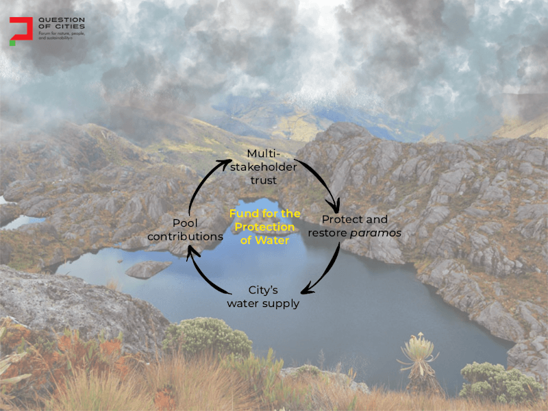
Two cities in the Global South show what second and third loop transitions can be, how ecological restoration can be turned into institutions. In Quito, Ecuador, the Fund for the Protection of Water (FONAG) has, since 2000, pooled contributions from the city’s water utility, private companies, and NGOs into a multi-stakeholder trust that protects and restores high-altitude paramo wetlands feeding the city’s water supply [6]. The fund is institutionalised rather than discretionary. This can help Bengaluru’s second loop reforms.
Durban in South Africa offers a glimpse of third loop transformation. Since the mid-2000s, the Municipal Climate Protection Program has expanded beyond pilot projects into a broader river management initiative, shared among the municipality, private companies and residents most exposed to flood risk [7]. Durban has incorporated this ecosystem-based approach into its statutory Spatial Development Framework.
Like these cities, in India’s cities too, the impacts of climate change are shaped not only by geography but also by decisions about urban growth, development priorities, and who benefits from them. Adaptive co-management offers one way to think about these challenges. Cities are complex systems shaped by interactions between people, infrastructure and ecosystems. It is difficult for any single agency to manage this. Adaptive management requires multi-level governance with close coordination between national, state and local governments, local communities and civil society, industry and social enterprise, integrating data-based inputs from scientists with heuristic local knowledge from nature-embedded communities like fisherfolk and street vendors.
Above all, adaptive co-management requires institutions to move beyond blueprint thinking that seeks universal solutions to try new approaches, learn from experience, and respond to changing conditions. The third loop learning plays a significant role in enabling cities to respond to novel crises by rethinking institutional design itself. Adaptive co-management does not replace planning; it makes planning more climate-responsive without relying only on crisis management while placing justice and representation at the centre of climate adaptation.
References:
- Karmakar, A. D. (2025, November 14). Delhi’s biodiversity parks show a face of urban ecological restoration. Question of Cities.
- Surin, S., & Dhagey, J. (2025, January 24). How urban plans can, and must, value trees. Question of Cities.
- BBMP, WRI India, & C40 Cities. (2023). Bengaluru Climate Action and Resilience Plan (BCAP). Bruhat Bengaluru Mahanagara Palike.
- Chennai Resilience Centre. (2019). Chennai Resilience Strategy. Greater Chennai Corporation and Resilient Cities Network.
- Delhi Disaster Management Authority. (2024). Heat Wave Action Plan for Delhi. Government of NCT of Delhi.
- The Nature Conservancy. Fondo para la Proteccion del Agua (FONAG). Quito Water Protection Fund.
- eThekwini Municipality. Durban Climate Change Strategy and Transformative River Management Programme. City of Durban.
Dr Arvind Lakshmisha is Assistant Professor at the School for Climate Change and Sustainability at Azim Premji University. He is an interdisciplinary researcher with a focus on understanding human-nature interactions around natural resource commons in areas under urban transformation.
Dr Harini Nagendra is Director, School of Climate Change and Sustainability, at Azim Premji University, Bengaluru. The recipient of multiple awards, her research on forest conservation and urban sustainability spans over 30 years. She has co-authored ‘Nature in the City: Bengaluru in the Past, Present and Future’; ‘Cities and Canopies: Trees of Indian Cities’; and ‘Shades of Blue: Connecting the Drops in India’s Cities’. She is an elected member of The World Academy of Sciences, Trieste; the Indian National Science Academy, New Delhi; and the Indian Academy of Sciences, Bengaluru.
All illustrations by Nikeita Saraf