
As a child growing up in Nagpur, the city’s lakes were its breath. A day out at Ambazari or Futala lakes was an event. Relatives who lived in the vicinity made it special. Down by the water, the air felt cooler. The dense tree cover offered protective shade. We lounged around for hours despite the heat, throwing specks of food to the fish, watching birds in rhythm, and munching on packed lunches.
Years later, I returned here as a researcher. The water in the lakes was not pulsating with life anymore; “development” had throttled its cooling nature. It was not only the lakes. Nagpur’s network of rivers, streams, and nullahs was turned into masses of concrete. And the city was paying a price for this with extreme heat. This brought to life, for me, Danish urbanist Jan Gehl’s words: “First we shape the cities — then they shape us.”
Nagpur forgot its water network
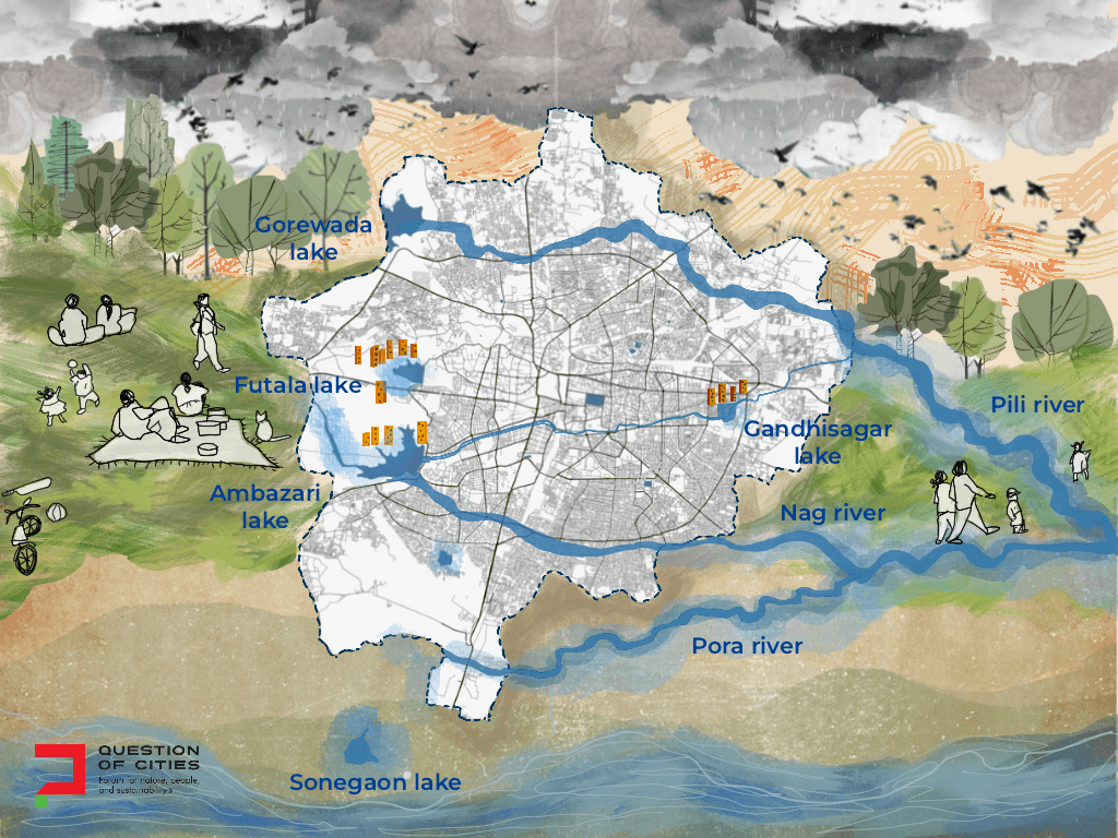
Every neighbourhood in Nagpur had some water body. The city’s network helped to keep the brutally high summer temperatures down. Nag River cut across the city from west to east, passing by old markets; Pili and Pora rivers flowed into it. During the monsoon, the rivers roared and dozens of seasonal streams came alive too, allowing water to meander across the city into ponds, and recharge the groundwater.
Research on urban rivers shows that when their banks are vegetated and their flow unobstructed, they can cool surrounding areas up to two kilometres.[1] Nagpur’s network of water bodies was its natural cooling infrastructure in summer and flood control during monsoons. A part of the larger Wainganga-Kanhan basin, the network comprised the three rivers – the Nag, Pili, and Pora – along with the Ambazari and Futala lakes, and Kanhan and Pench rivers on the city’s outskirts that supplied drinking water. The Nag, originating in the Lava hills, gives the city its name and flows about 16 kilometres in the urban stretch, subsuming the Pili and Pora, before it meets Kanhan.[2]
As with most urban waterbodies, Nagpur’s lakes and rivers have been turned into open sewage drains. Forced to act, the Maharashtra Pollution Control Board prepared the Nag River Basin Action Plan in 2011. For a decade, the river continued being filthy. In March 2021, the more comprehensive Rs 2,117.54 crore Nag River Pollution Abatement Project was formally approved by the central government.[3] Five years later, the river is still a conduit for industrial effluents and untreated sewage discharged in the Hingna MIDC belt; these flow down to the Ambazari Lake.
Over decades, several small and isolated decisions of construction with a cumulative and disastrous effect have led to the rivers, lakes and streams being channelised, their banks cemented, and all vegetation and biodiversity removed. The natural network was done away with, one at a time. The water bodies now cover barely 1.08 percent of the total city area (2.29 square kilometres) which is a sharp decline from the 5.76 percent (12.2 square kilometres) recorded in 2000.[4]
There are plans for rivers; none for lakes. In the city’s west is Ambazari, the largest, across 370 acres; Gorewada, across 257 acres, lies to the north-west and is hemmed in by forests; Futala in the central-west with 91 acres and Gandhisagar in the south of the old city at 44.4 acres form the set. They still do their job to an extent.
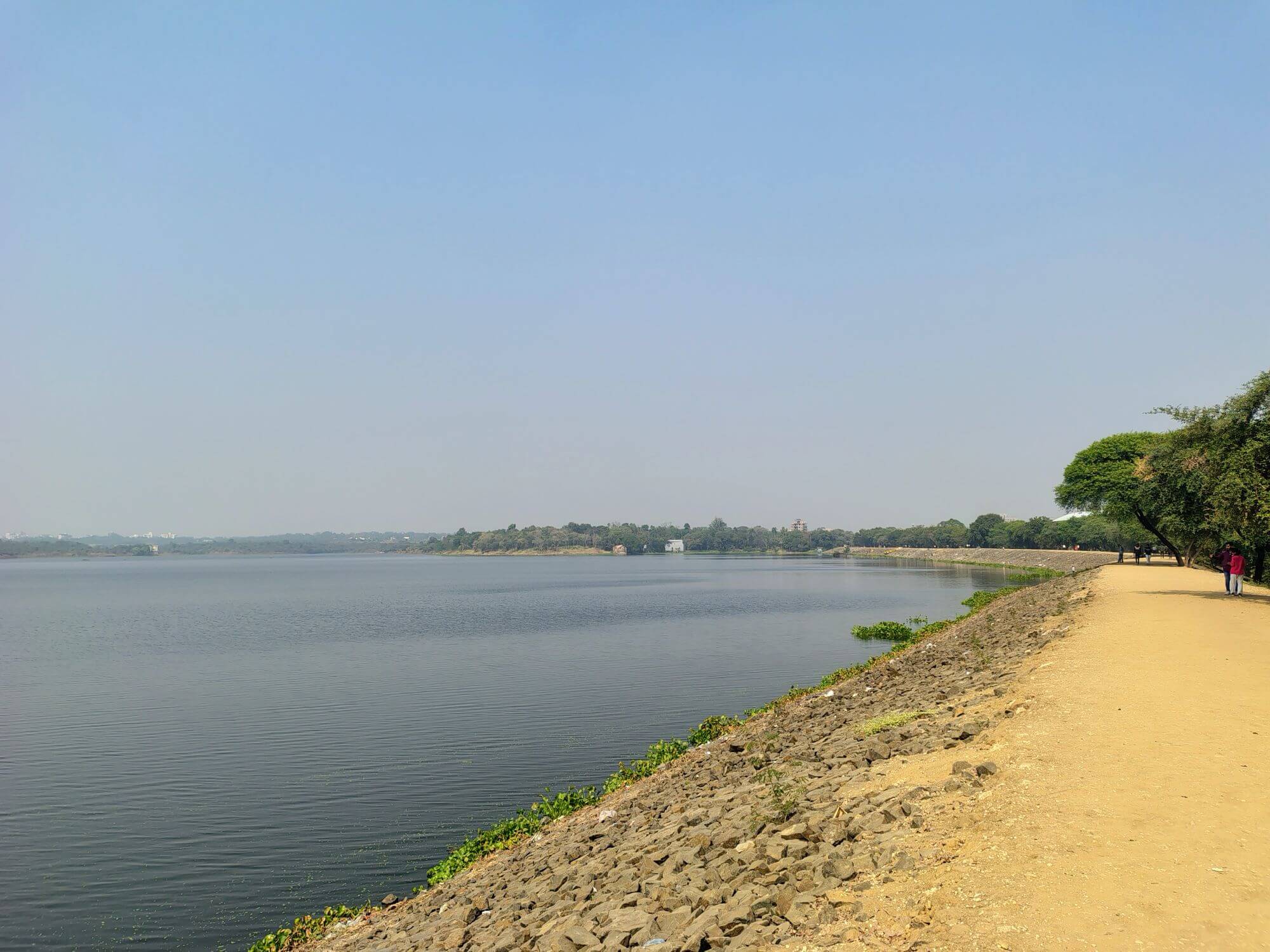
Photo: Aniket Sawargaonkar
Concrete by design
With my researcher’s skills, I set out to test the impact of lakes on surrounding areas. Satellite thermal data from May 29, 2024, at the height of a severe heat wave when Nagpur’s ground temperature was 47.63 degrees Celsius, that I analysed for my dissertation, showed that neighbourhoods in direct vicinity of the lakes were cooler by four to eight degrees Celsius. In a city where 86 percent of the expanse shows routine summer temperatures above 36 degrees Celsius, this margin is not a matter of mere comfort but a question of survival for many.
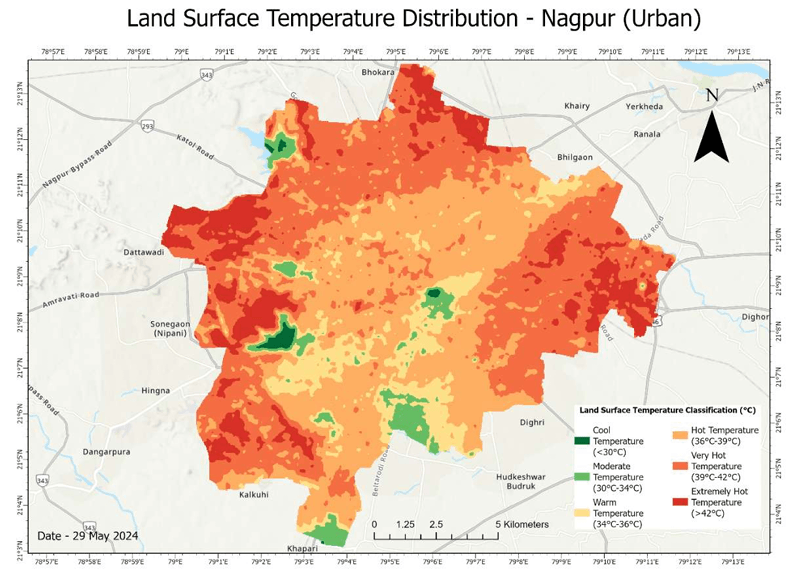
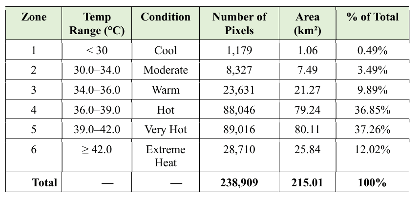
Given its impact, the natural network of water bodies should not have been interfered with and fractured or built over. Instead, the city was built near, over and into them – by design. Concrete was poured into water or near it by deliberate choice. Nagpur has been built and expanded without factoring in its water network.
The numbers show how much. Between 2000 and 2023, when the city’s water bodies diminished by 81 percent,[5] area more than doubled to 185 square kilometres.[6] My research showed that eight water bodies were landfilled; the rest steadily now being encroached. But the built environment does not build itself. Someone signed the development permissions, someone approved the concrete embankments.
Take Ambazari, the thermal refuge. A stretch of 1.2 kilometres of a once-natural shoreline has concrete all over. Industrial effluents from Hingna MIDC make their way here via the Wadi nullah. There is water hyacinth, thriving on the nutrient load of raw sewage and smothering 30 to 50 percent of the lake surface, robbing it of its capacity to breathe.
Futala’s story is no different. An early 20th century construction in ward 28, Nehru Nagar, is hemmed in by commercial and residential density. Ecologically, the lake is in poor shape, with severe water hyacinth infestation[7]. Yet, Nagpur Municipal Corporation (NMC) and its partners chose to spend Rs 200 crore and more on beautification – a floating musical fountain, decorative lights, viewing gallery, and parking plaza – rather than ecological restoration.
Swachh Association Nagpur filed a Public Interest Litigation, contending that 7,000 tonnes of concrete had been dumped in the lake bed in contravention of wetland rules[8]. The Supreme Court paused work but the appeal was dismissed in October 2025. The state government’s position was accepted: Futala is a human-made lake, not a wetland.[9] In broad daylight, a water body critical to one of the densest areas of Nagpur was simply re-classified, its protections removed, and a fountain installed.
Who decides how much of the water bodies can be built over? Ideally, there should have been a map of the water bodies network, urban plans factoring it in, and permissions to build given only with strong caveats to protect it. The NMC acknowledges only five lakes, according to Right to Information (RTI) data available; most water bodies fall under fragmented jurisdictions with no single agency responsible, and no funds had been received under the state’s dedicated lake conservation scheme in recent years.[10] Fragmented ownership, zero funding for conservation, and a Supreme Court judgment that says the most-visited lake is not legally a lake – these together decided that Nagpur could build against its water network.
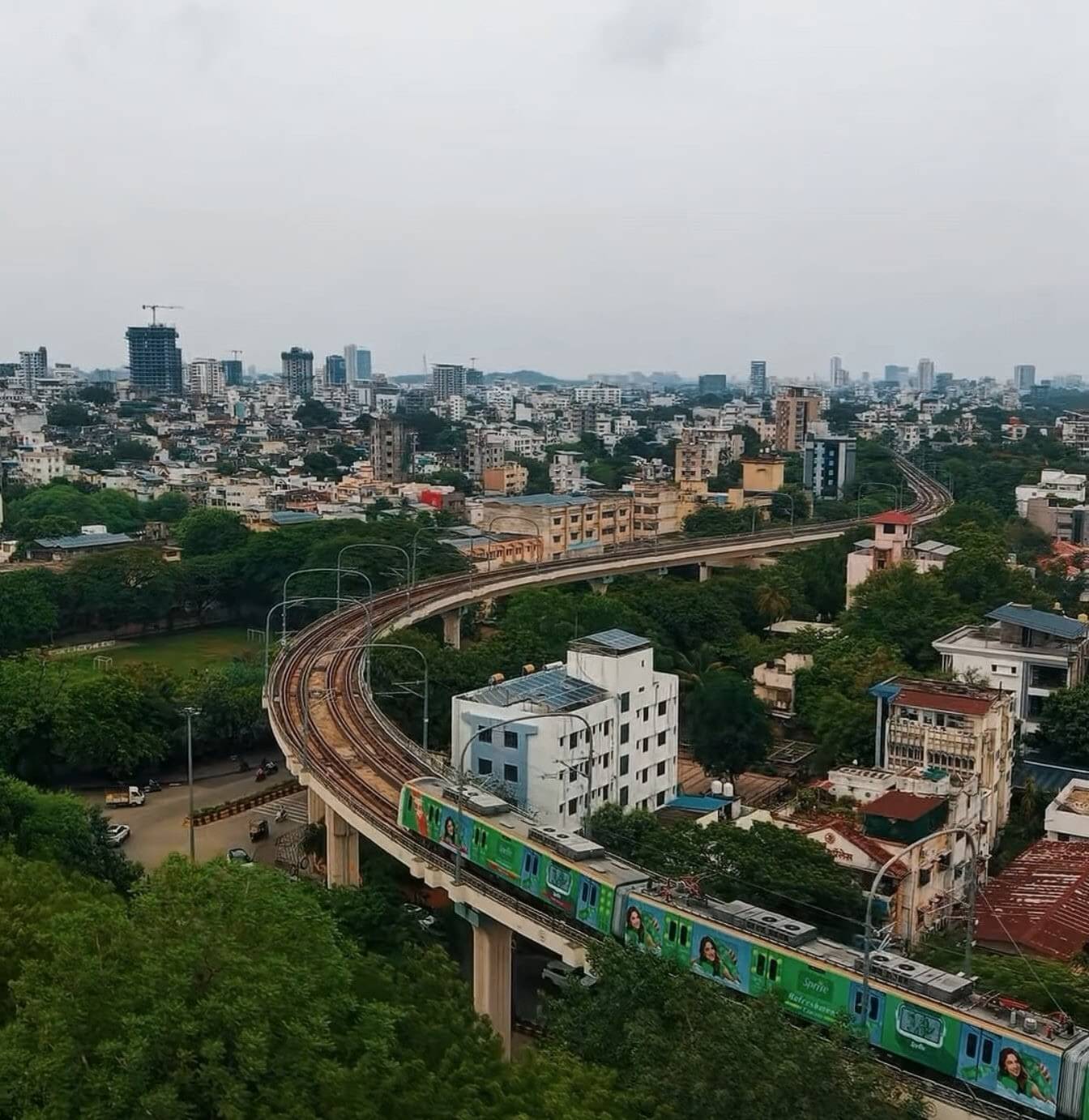
Photo: Wikimedia Commons
Who bears the cost?
The May 2024 data of heat that I had recorded at 41.2 degrees Celsius was an average which concealed the geography of inequality. The eastern and south-eastern wards with many informal settlements, home to 23 percent of the city’s population, recorded mean temperatures above 43 degrees Celsius that day. My research showed that the wards with the lowest green cover and fewest water bodies, concentrated in eastern and central zones of the city, had high density of outdoor workers and informal settlements.
A 2024 peer-reviewed study by researchers at the University of Edinburgh found that cycle rickshaw pullers and homeless people face severe heat exposure with almost no adaptive capacity, no shade, no cool spaces, and no institutional protection.[11] A study by the Visvesvaraya National Institute of Technology (VNIT), Nagpur, documented the same: Informal workers perceived the heat risk but had no viable means to escape it[12].
Dr Rajashree Kotharkar of VNIT, who authored the draft model Heat Action Plan for India’s cities, notes that the worsening heat waves have impacted outdoor and informal workers the most. Nagpur has a Heat Action Plan. It calls for hospitals to set aside ‘cold wards’ and advises builders to give labourers a break on very hot days; it does not address the systematic destruction of the city’s natural cooling system that workers depend on when they are not on a construction site.
My research shows the impact of the neighbourhood natural systems. Ward 12 (Dharampeth) has the highest heat vulnerability score; the mean land surface temperature is 42.1 degrees Celsius. Its nearest wetland is 2.8 kilometres away, unreachable on foot in the midday May heat. Ward 20 (Gandhibagh) has three water bodies nearby including Gandhisagar, whose cooling zone covers roughly 18,200 residents. The area is cooler despite the lake bearing industrial pollutants and surrounded by concrete embankments on its northern and eastern edges.
When Nagpur’s temperatures climb past 45 degrees Celsius, the risk of mortality goes up by half.[13] Yet, the city’s plans have done little to protect its water bodies in order to shield people. Even in the heat conversations, the deliberate shrinking of water bodies is hardly discussed.
Restoration, not fountains, is the way forward
Beautification is no substitute for restoration. Consider the Nag River Rejuvenation Project. It finally got the go-ahead in 2019 but seven years later, it has only a management consultant and an 88-month timetable[14] while the condition of the river remains unchanged. Then, there is Gandhisagar lake. The AMRUT project for lake restoration has moved through stages of draining and sheds built on its edges, but cleaning work lies unfinished while the NMC plans an ornamental fountain in the decaying water. Yet again, constructed beautification replaces ecology.
After the unfortunate outcome in the Swachh Association case in the SC, citizens have virtually no recourse to demand answers from the NMC about the lakes. In fact, as an RTI probe showed, its ownership is in question. What would ecological restoration entail? Clearing the encroachments on their shores, making the 100-metre green belt around them as per the Nagpur Development Plan 2041, intercepting sewage and effluents from Wadi and Hingna MIDC flowing to Ambazari, and stopping the construction of concrete embankments in place of the water’s natural edges and riparian zones.
The NMC should approach lake restoration as an ecological infrastructure project, not mere maintenance of a park; simultaneously, building plan approvals must protect the water bodies. The Maharashtra government should plug the legal loophole that allowed Futala to lose its wetland tag so that it, and other water bodies, are protected. The AMRUT programme must be judged on ecological results rather than fountains or viewing galleries constructed.
Even if the authorities were to look at economics, the argument to restore Nagpur’s water bodies network holds. My research indicates a return of over five rupees for every rupee put into Ambazari over a 30-year period after factoring in flood control, carbon sequestration, urban cooling and recreation. Compared to the Rs 1.28 return on the Outer Ring Road, and the ecosystem value of the wetlands, there is no reason to not restore Nagpur’s water bodies – except the lack of political will.
What Futala says
I was back at Futala recently. In the harsh summer haze, the water glistened greenish-grey, the trees on its banks were sparser than in my memory, people were strolling to catch some of the cool breeze at the lakes’ edges. But a fountain was being built too. Nagpur was still building or “developing” without a thought for its water bodies network.
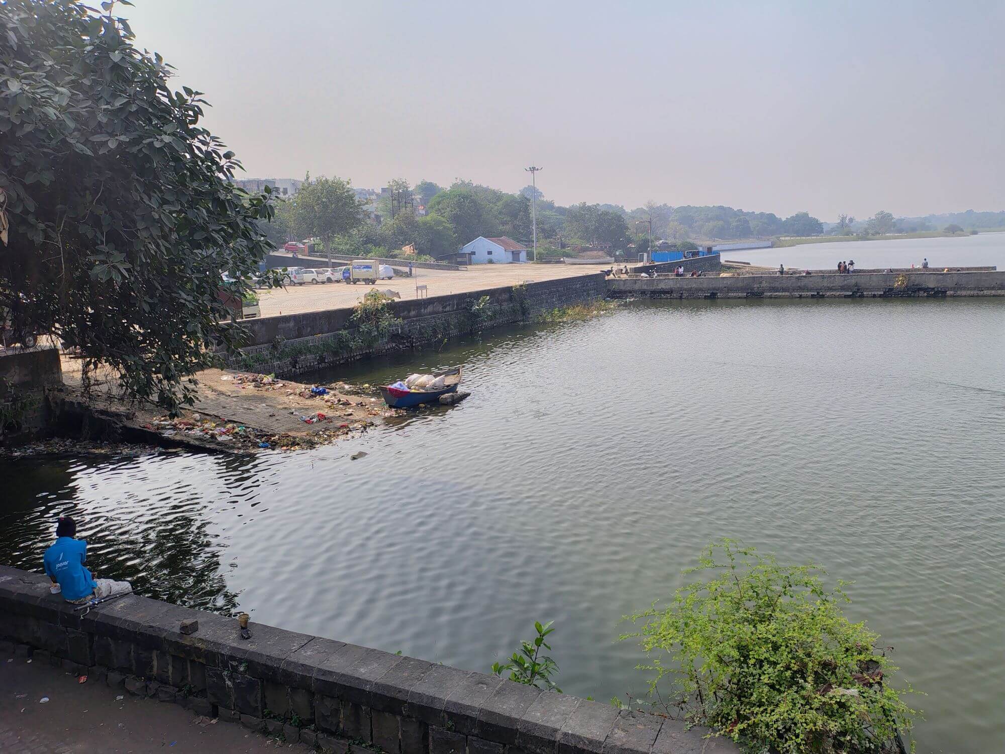
Photo: Aniket Sawargaonkar
The city we were given, with its water, fish, birds, and cool air which made summers slightly bearable, was no fluke but the outcome of a water body network. All that is being traded for concrete and called “development.” In a city projected to hit 48 degrees Celsius, these are essential cooling infrastructure, not canvases for beautification. The rickshaw pullers, the construction workers with no shade, the families living in tin-roofed houses did not decide to build the city this way but they face the most adverse impacts of such ecologically-unsound built environments.
Nagpur can still be reshaped and built around its water bodies.
Aniket Sawargaonkar is a researcher and disaster management professional. He holds a Master’s from the Jamsetji Tata School of Disaster Studies, Tata Institute of Social Sciences, Mumbai, where his dissertation focused on the integrated spatial and economic valuation of urban wetlands in Nagpur.
Cover illustration: Nikeita Saraf