
The relationship between land and water in cities is not fixed. Acknowledging the true nature of rivers not as fixed channels but as dynamic systems constantly in flux, moulding the landscapes they flow through and getting reshaped, is the starting point of sustainable and sensitive urban river management. Overlooking or disregarding this nature of the relationship is an invitation to disaster.
In cities, systems like roads and railways are seen as infrastructure and carry a stamp of permanence. Unlike them, rivers are more ephemeral, changing seasonally and regionally. Increasingly, we see the dangerous pattern where rivers in cities are treated as resources for extraction or places of expulsion. Exploitative interventions on the edges of a river forcibly alters its course, its riparian zones are subject to abuse through excessive use of concrete to build promenades, felling of native species, and erratic channelisation and damming.
These and similar unchecked Anthropocene interventions disrupt soil conditions of the riparian zones which further constrains the lateral movement of the river and, subsequently, impedes its geomorphic processes. The dynamism of the river, over centuries, helped sculpt landforms and sustain ecosystems; their behaviour and life cycles evolved in harmony with the river’s natural rhythms. Rivers in cities should be recognised as active geological and ecological forces, not as passive waterways that we can control.
However, India’s regulatory frameworks for river management show a pattern of prescribing fixed distances for buffer zones. These contradict the very nature of a river whose edges are never fixed but shift with its changing course. Policies oversimplify the fluid boundaries into hard lines. The smallest interventions can disturb the equilibrium of the entire riverine ecosystem and destabilise its interrelationships. The damage goes beyond the buffer zones and percolates into declining water quality, increased fish mortality rate, and unstable banks. Over time, the floodplains erode and we witness a collapse of natural systems that once mitigated floods and replenished groundwater with far greater efficiency than engineering solutions ever could.
Given this, it becomes imperative for Urban Local Bodies to recognise the symbiotic and dynamic relationship between land and water in cities, and adopt policies that reflect the changing nature of rivers.
Beyond fixed-width riparian buffers
Riparian buffers are defined as vegetated corridors adjoining rivers, streams, lakes, or other natural water bodies that function as transition zones between terrestrial and aquatic ecosystems. They perform a range of essential functions such as maintaining water quality, sheltering biodiversity, stabilising riverbanks, filtering pollutants and excess nutrients, aiding groundwater recharge, and, above all, moderating the impact of floods.[1] How much buffer a river requires depends on the character of the river itself.
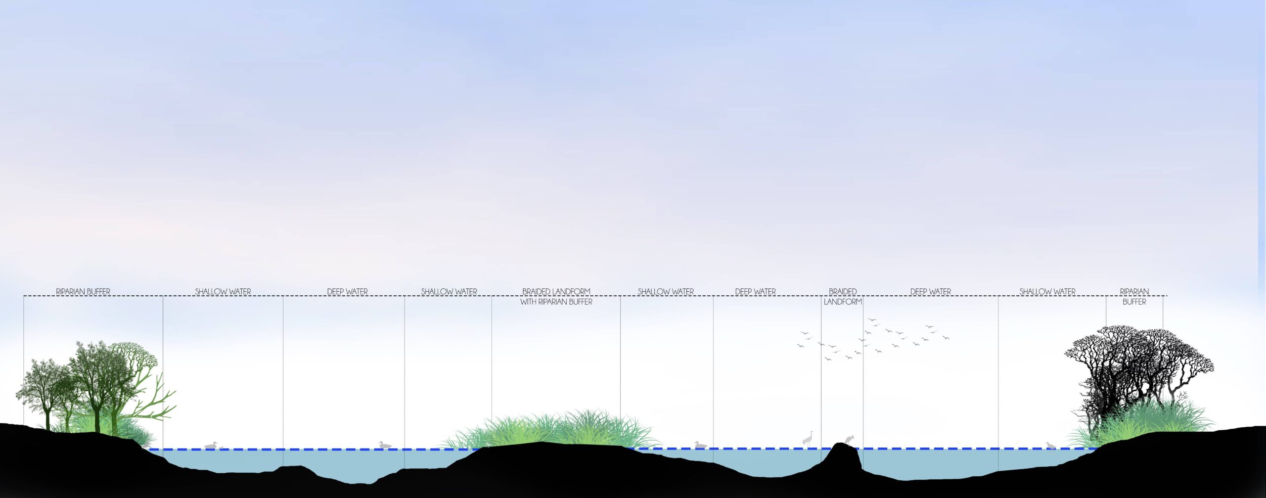
Illustration: Authors
India’s environmental regulations and directives of the National Green Tribunal recognise and protect these zones through prescribed no-development setbacks. Yet, a riparian buffer is more than a regulatory line. It is a living system, its extent and behaviour shaped by the continual interaction of water, soil, vegetation, wildlife, and seasonal flows. A river can show markedly diverse landscapes along its course; rivers in different climatic and geographical settings differ even more.
The Ganga illustrates this. Near its source at Gangotri Glacier, it runs through steep, rocky Himalayan terrain in a narrow, fast-flowing channel where a slender buffer is sufficient to stabilise the slopes and check erosion. As it descends into the plains of Uttar Pradesh, it slows and broadens, migrating across the landscape and dividing into multiple channels. This restlessness calls for a wide buffer that can absorb seasonal inundation and the movement of sediment. In Bihar, sediment-laden tributaries such as the Ghaghra, Gandak, Kosi, and Son widen the floodplain further; the river may abandon established courses for new ones. Near its mouth, the Ganga joins the Brahmaputra to form the Sundarbans – the world’s largest delta and a UNESCO World Heritage Site – where the buffer’s role shifts to safeguarding tidal and estuarine habitats.
Rivers vary across space as well as time. During the monsoon, floodwaters extend well beyond the visible channel, creating temporary habitats; in the dry season, they recede and expose land that sustains an entirely different ecological community. Climate change is likely to intensify these fluctuations. This is the crux of the matter. A buffer accommodates what the river does – carrying and depositing sediment, exchanging water with the ground beneath, shifting its course, flooding, and receding. Its width, accordingly, should be determined by these processes rather than a uniform line on a map. Planners and policy makers must reflect: If a river’s character varies so greatly across landscapes and seasons, how can a single standardised setback adequately protect it?
The diverse conditions along the Ganga suggest that no fixed-width buffer can accommodate a river’s dynamic processes. Yet, urban planning frameworks continue to favour fixed widths and blanket regulations for administrative ease, at the expense of ecological reality. This tendency is compounded by the fragmented structure through which river protection is conceived, implemented, and enforced. Across the patchwork of national environmental regulations, NGT directives, the Floodplain Zoning framework, disaster management apparatus, and local development control rules, the single assumption is that a river can be safeguarded by a predetermined distance from the water’s edge.
Gaps in the existing frameworks
The National Floodplain Zoning Policy, 1975[2] asks states to map floodplains according to flood frequency and risk, but the response has been thin. Only four states – erstwhile Jammu & Kashmir, Uttarakhand, Manipur, and Rajasthan – enacted floodplain zoning regulations but enforced little. Into this vacuum, states have decided fixed numbers. In Maharashtra, for instance, the Unified Development Control and Promotion Regulations (UDCPR) permit riverfront development beyond a green belt of just 15 metres from a river and nine metres from a nullah.[3]
Across the country, authorities behave similarly, varying only in the number they pick as the table below shows.
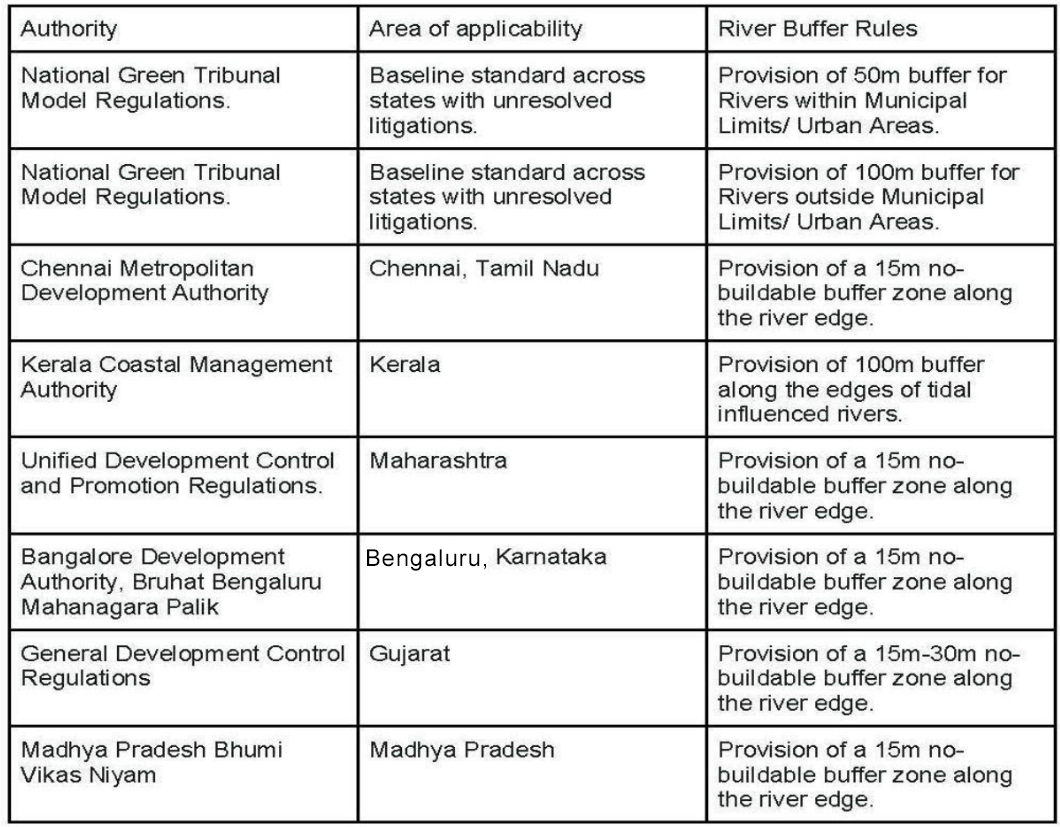
The pattern is hard to miss. From Chennai to Bengaluru to Madhya Pradesh, the favoured tool is a single figure – usually 15-metre no-build zone – applied the same way whether the river is a narrow city channel or a wide, wandering one. The NGT’s own benchmark of 50 metres within city limits and 100 beyond sets the tone; states tend to follow it.
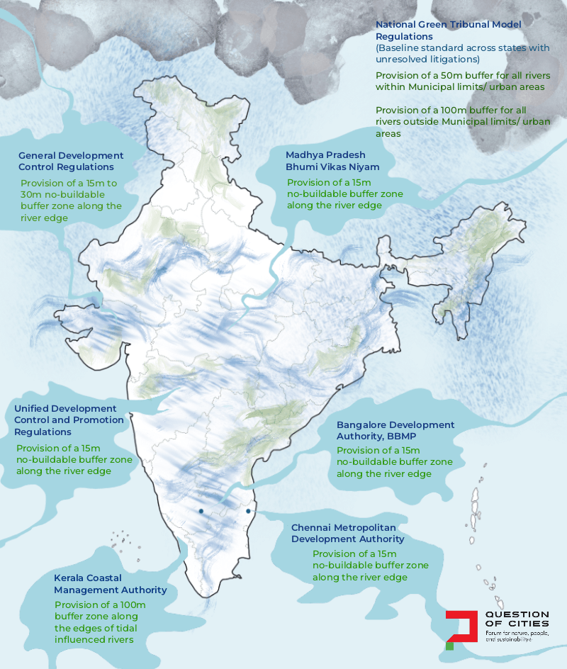
Illustrated map: Nikeita Saraf
The gap between principle and practice
The limitation of this approach becomes clear around Varanasi where the Ganga behaves as a mature meandering system – its active floodplain, point bars, and abandoned channels recording a long history of lateral movement[4] The river’s footprint extends well beyond its visible channel; its shifting interaction with the floodplains cannot be contained within a fixed line. Yet, the directives continue to rely on fixed-width buffers. See the table below.
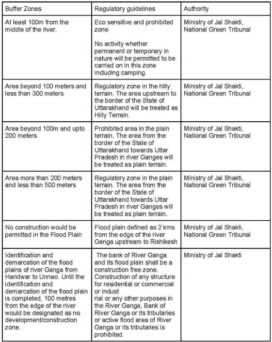
Herein lies the contradiction. The 1975[5] Policy was founded on the idea that floodplains must be mapped scientifically from how a river behaves. The Ganga rules treat the 100-metre buffer as a stopgap until the floodplain is properly identified and demarcated. But the stopgap became the line of governance.
The provision of a fixed-width buffer helps to determine where development can be done but fails to provide for riparian landscapes of a living river. Compliance, then, means respecting this line on a map rather than ensuring the continuation of the river’s processes. Without ecological, morphological, and hydrological performance criteria, riparian buffers become residual spaces that lack an articulated purpose. The Sabarmati Riverfront Development,[6] now the template followed in cities across India, shows how such regulations can systematically destroy the very floodplain system they claim to safeguard.
Riverfront development and buffer zones
Rivers in several Indian cities have seen, or are seeing, riverfront development presented as flood control and beautification initiatives.[7] Yet, the outcomes invariably harden the permeable, soft edges of rivers through engineered embankments and manicured public promenades often at the cost of hundreds of trees. While these seem attractive to the public and real estate developers, they endanger the river’s health and disrupt its ecology. The Mula-Mutha riverfront development in Pune is a significant case study.
The Pune Municipal Corporation made a public presentation of the RfD proposal for varying interventions along the 44-kilometre stretch of the Mula and Mutha, followed by a question-and-answer session. Though it acknowledged varying types of embankments depending on the river’s edges, the design interventions of RfD did not recognise their fluidity. Instead, the riparian sections were fixed into pre-determined profiles and static planting zones rather than dynamic buffers that would respond to seasonal flows and erosion deposition cycles.[8]
Continuous sloped embankments were proposed regardless of local geomorphology which threaten to flatten the ecological diversity. The planned native plantations here could, in no way, replace the layered and self-regulated riparian ecology that had evolved over centuries.
Another important point was that flood mitigation and biodiversity were treated as separate objectives, addressed independent of each other. In reality, they are inseparable; porous riparian buffers themselves are effective flood mitigation infrastructure. Like the Sabarmati model it emulated, the Mula-Mutha RfD too leaned towards confining the river into a predictable channel stripped off of its self-regulating capabilities. River-sensitive urbanism asks for the reverse: Interventions that respond to the river’s inherent uncertainty rather than confine it to static templates.
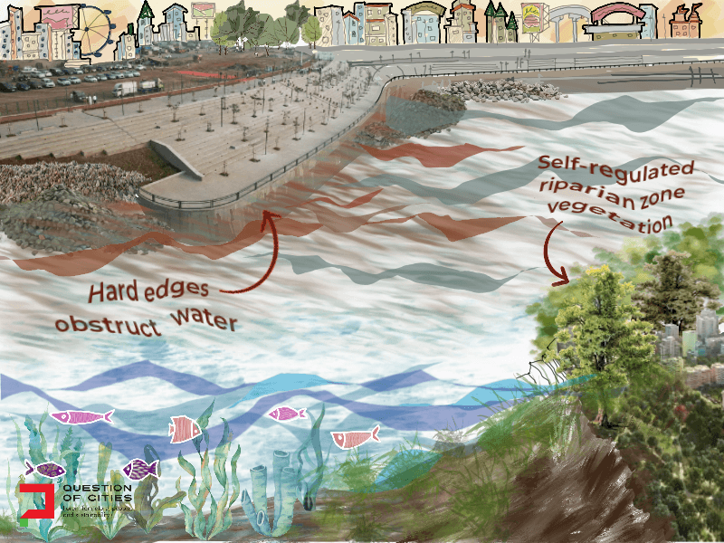
Illustration: Nikeita Saraf
Proposed framework and ways forward
The way out of this is a context-responsive, robust approach wherein the interaction between the river’s hydrological, ecological, and geomorphological processes are not only recognised but also protected so that dynamic landscapes evolve with the river.
- Deciphering the river-watershed relationship:
Unlike built infrastructure, rivers are not governed by administrative boundaries but interconnected processes that include the nature of the source of water, geological formations, catchment characteristics, geomorphological processes, hydrology, hydro-geology, sedimentation dynamics, drainage network, land use patterns, and seasonal flows. There is channel behaviour such as migration, formation of braids, erosion, deposition, flooding and ecological resilience. This river-watershed relationship should form the basis of all management measures. - Delineation of active floodplains:
The river-watershed relationship study should be followed by a scientific delineation of active floodplains. This can be achieved by superimposing multiple data sets such as historical flood records, high flood line (HFL), topographic data, channel migration records, flood-frequency assessments and sediment transportation patterns to determine the true extent of the active river floodplain and its relationship with the adjoining ecosystems. Such an evidence- based study should be the foundation of context-responsive planning and inform site-specific, detailed, longitudinal and cross-sectional surveys to categorise the river into terraces. - Assigning ecological performance criteria:
Each terrace should be assigned ecological performance criteria that will guide the planning and management interventions to maintain river health, ensure hydrological continuity, enhance ecological resilience and reduce flood risk. While the ecological performance criteria assigned to each terrace remains synonymous across river systems, the planning and design interventions will vary depending on the context. - Policy shift from zoning to ecological reasoning and valuation:
Once these zones are established, baseline ecological assessments will need to identify measurable performance indicators. Emerging approaches like Natural Capital Accounting (NCA)[9] can be used to derive indicators aligned with the UN SDGs. Some measurable indicators include
-
- Provisioning services which include fresh water supply, fisheries, irrigation
- Regulating services comprising flood attenuation, groundwater recharge, water purification, erosion control, climate regulation, carbon sequestration
- Supporting services such as habitat provision, biodiversity conservation, nutrient cycling, soil formation, ecological connectivity
- Cultural services including recreation, tourism, aesthetic value, cultural heritage, spiritual significance.
The valuation approach translates ecological functions into economic terms that both planners and courts can understand. This offers a potent legal and economic argument against extractive pressures in buffer zones.
Conclusion
India’s cities must re-evaluate approaches to river-sensitive urban development. Planning should be around a river’s ecological limits. Floodplains and conservation zones should be scientifically identified before plans are prepared rather than the other way around. And urban plans must adapt to rivers, not force rivers to adapt to them.
A key step in this process is to recognise rivers and riparian buffers as ecological infrastructure that provide valuable services. The cost of undermining these is enormous. The Central Water Commission data highlights the losses incurred through average annual flood damage amounting to about Rs 6,972 crore since the 1950s.[10] These figures capture only a fraction of what is lost when river systems decline.
Therefore, fundamentally, buffers should not dictate the river; the river should dictate the buffer. The central question that cities must ask is not how much riverfronts can be developed but how development on river edges can be balanced without compromising ecology.
Resham Mehta is a practising landscape architect and academician based in Mumbai, India. She believes landscapes are not mere aesthetic additions but the essential infrastructure of cities. Through her writing, she advocates for urban environments that are ecologically sensitive, people-centric, and designed in harmony with nature.
Rama Raghavan is an architectural writer and researcher based in Pune, India. She sees multidisciplinary thinking as essential to richer design conversations. Her work sits at the intersection of critical writing and project-based storytelling, and has appeared on platforms including Hammock Magazine, Mongabay India, ThinkMatter, Architecture LIVE, and My Liveable City. Through her writing, she traces the social life of spaces, advocating for design that is sensitive, inclusive, and deeply human.
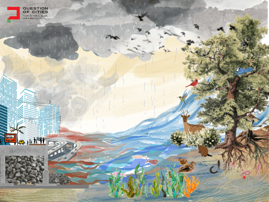
Cover Illustration: Nikeita Saraf