Ahmedabad, Gujarat’s commercial capital, finds a place among the top five smart cities in India. It was honoured with the Smart Cities Leadership Award two years ago by the Union Ministry of Housing and Urban Affairs, which launched the Smart Cities Mission in 2015. The Mission, which identified five cities in Gujarat, describes a smart city as “a city that works”. The obvious implication is that it must work for the people who live in it. Water management is among the categories for which cities are allocated grants under the Mission.
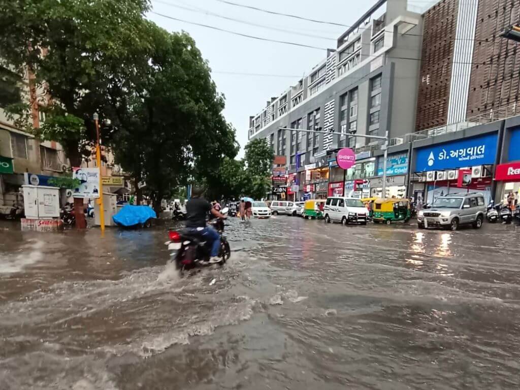
Ahmedabad is far from smart, clearly, when it comes to water or flood management. It looks more an unplanned urban disaster than a smart city every time the skies open up with moderate to heavy showers. Flooded roads, struggling people, stranded vehicles, water and power supply cut in the affected areas, potholes and waterlogging – all characteristics of modern Indian cities in monsoon. If water management is among the key areas to decide if a city works – and it should be – then the Ahmedabad Municipal Corporation and the Ahmedabad Urban Development Authority (AUDA) fall woefully short and appear blissfully unaware of the challenges that lie ahead.
Every monsoon is turning out to be a great leveller in Ahmedabad which otherwise is a study in historical, economic, and social contrasts. The UNESCO-certified heritage city has flooded roads and stranded people battling the elements and the maladministration. This year, so far, it has happened twice in July and September. Most of Ahmedabad was affected – from the worst-hit informal settlements or slums in the eastern industrial suburbs and narrow lanes in the walled city to flashy commercial complexes, swanky independent bungalows and residential societies in the western parts, and also arterial roads such as Ashram Road, CG Road, SG Highway and the upmarket Prahlad Nagar Road all of which resembled ponds.
Along with the flood and waterlogging, Amdavadis also frequently face road cave-ins. There were 29 incidents of roads caving in after a heavy shower in a fortnight in July, according to the Ahmedabad Municipal Corporation’s (AMC) data; 12 of these were in the supposedly better managed western zone of the city. Data shows that the municipal corporation repaired as many as 557 road cave-ins during the past 10 years. Through this – floods, waterlogged areas, road cave-ins – people suffer, especially the poorest among them.
Crux of the problem
There are several reasons to which the annual incidents of flooding and waterlogging can be attributed, but the one over-arching reason is the management – rather the mismanagement – of the city’s natural waterbodies and rain channels. There has been a staggering 80 per cent decline in the number of lakes in Ahmedabad from 1999 – an outcome of the rapid and ecologically unsustainable urbanisation that is rarely discussed.
“There were 630 lakes of various sizes in Ahmedabad in 1999, that number stands at 122 only today,” said Mansee Bal-Bhargava, urban planner who studies lakes and waterbodies in the city. Where did more than 500 lakes vanish? During her doctoral research, she found that there had been “a systematic exclusion of waterbodies from urban planning to facilitate real estate growth.” Ahmedabad’s expansion has come at the cost of its natural waterbodies.
At the national level, the National Lake Conservation Plan was charted out in 2004 to identify and designate lakes so that they could be protected from encroachment and subsequent disappearance; the implementation started, on paper, three years later. Renamed in 2015 as the National Plan for Conservation for Aquatic Ecosystems (NPCA), states drew up different criteria to define a lake. Often, the definition was flexible enough for a waterbody to not even be counted as a lake.
Across Gujarat, according to Bal-Bhargava, the definition was that a waterbody should have a natural water retention of 10 years to be designated as a lake. “The few such lakes and most of the others which were shallow, therefore, got excluded from the official list of lakes. This simply means that all that area became available for real estate development and construction. I call it water-grabbing.”
The Ahmedabad Municipal Corporation exemplifies this. Two years ago, officials had identified 142 water bodies as possible stormwater outlets; 33 of them on the outskirts of the city were included too. However, 26 of these 33 had not been designated as lakes and, instead, had been allotted to various government departments and firms for construction. These lakes, now officially revenue land, are ear-marked for projects such as the Ahmedabad-Mumbai bullet train, police housing, police stations, Electronic Voting Machine (EVM) godown, Hindustan Petroleum company and government employees’ quarters.
The 33 identified waterbodies matter because they cover over nine lakh square metres of land and are close to as many as 45 heavy waterlogging areas – they were, and could have continued to be, stormwater sinks during heavy rainfall. That water now floods areas.
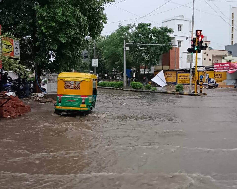
Photo: Damayantee Dhar
Waterbody as land for sale
The rainwater has nowhere to go and, worse, there is more rainwater to manage – two reasons which lead to flooding, said Vaishali Kushwaha, Environment, Sustainability and Resilience Scholar at Northeastern University, Boston, who has drawn up a unique Paani Ka Maanchitra: Water Map of Ahmedabad, graphically tracing the water history of the city. “Bad planning and wrong priorities” of the government are the reasons for flooding, she told Question of Cities from Boston where she is based.
This means that when the Ahmedabad Urban Development Authority (AUDA), private developers, homeowners and industries convert open spaces into ‘developed’ land, they hardly study the natural flow of water, which leads to new construction without providing channels for the rainwater to flow out.
“In olden times, people understood the idea of talavdi (ponds or small lakes) and tekro (higher ground). They constructed houses on higher grounds and built ponds and wells on the lower ground. Each village had multiple talavs. They built walkways or galli along the natural slopes to ensure that rain water easily flowed down towards the talav. Now that all land is seen as an economic good to profit from, both tekro and talavdi are land for sale,” explained Kushwaha.
There could not be a clearer linkage between flooding and lack of green spaces to absorb the rainwater. The small talavs which acted as reservoirs for rainwater have buildings or parks, pucca roads have been constructed but not enough stormwater drains, outlets, or storage for carrying the rainwater safely have been built. When it rains heavily, the water has no lake or talav to go to, and flows to low-lying open areas such as parking lots and roads which get waterlogged.
Experts in the field have been trying to draw attention to the aspect of increased rainwater which needs to be managed. One, there is more runoff given the increase in paved surfaces and haphazard real estate development. Second, Climate Change plays an inescapable role. “Rather than slow showers over a week, we witness sudden downpour in a few hours. This results in a large amount of rainwater in a short time. The land cannot absorb water as fast and a lot more runoff is generated. This means urban planners and civil engineers need to upgrade their design calculations and find new solutions,” said Kushwaha.
Another aspect of mismanagement is in the existing limited stormwater drainage network: Drains and wells are mostly blocked with waste and debris which reduce the carrying capacity of the stormwater system, also the drains are 50 years old and cracked. Civic officials agree, in private conversation, that nearly 200 out of the 980 square kilometres of ageing stormwater drainage network frequently crack under pressure. The “problem” stretches are known internally and includes many in the city’s commercial and upmarket areas.
Rejuvenation or slow killing?
Some noise made around the destruction of lakes and other waterbodies has led to the spree of rejuvenating them. However, under the garb of rejuvenation which is a complicated ecological project, areas around the waterbody are heavily concretised which further compromises the natural area. The Sabarmati Riverfront project and Vastrapur Lake are two examples of how concretisation and beautification have come to mean rejuvenation.
“They are killing whatever is left of lakes by a faulty model of concretisation. As a result, such a lake becomes a good picnic spot but turns into a real estate project,” pointed out Mansee Bal-Bhargava. Vastrapur Lake used to be a natural channel for rainwater; under rejuvenation, squatters were removed and it has been concretised. “The environs of the lake are good for morning walkers and picnickers, but the water filled into it is treated domestic sewage water. The land prices have sky-rocketed in the area after the redevelopment of the lake but rainwater does not flow into the lake,” she explained.
Similarly, the concretised part of the Sabarmati River resembles a tank of stagnant water filled with Narmada dam waters. Though the Sabarmati Riverfront is showcased as a major achievement, beyond the riverfront is a 120-km nearly-dead river. Many such picnic spot lakes, including Kankaria lake, are similarly filled with Narmada dam water. “Lakes are supposed to work as natural drains as well as groundwater recharge zones, but the entire purpose is being defeated by blocking up the drains. What else do you expect but flooding even by meagre rainfall?” pointed out environmentalist Mahesh Pandya.
Researchers have found that Ahmedabad has only 12.3 per cent green cover while the blue infrastructure, which means lakes and waterbodies, covers an abysmally low 2.2 per cent area, and this too is degrading by the day.

Photo: Wikimedia
Built spaces replacing water bodies
The flooding in Ahmedabad, as in other major cities of Gujarat, with even little rain is linked with the larger question of how ‘development’ is defined. In common understanding and public discourse, this has come to mean construction – and more construction – without accounting for the natural areas getting denuded.
Most capital projects taken up by the Gujarat Government and inaugurated by the Prime Minister or union Home Minister in the last few years are related to roads and bridges, building new highways or expanding existing ones, or creating massive townships. All these involve huge construction activity and real estate work, most of which is done over – not around – the existing water bodies where they are listed. Construction is also done on waterbodies which do not show in any document as such.
This trend of more than four decades, through successive governments, has led to an expansion of built spaces. A study “Monitoring land use changes and its future prospects using cellular automata simulation and artificial neural network for Ahmedabad city, India” by the state government’s Bhaskaracharya National Institute for Space Applications and Geoinformatics (BISAG) and Central University of Gujarat (CUG), of land-use patterns from 1974 to 2017 had projected that built spaces are likely to cover the majority of area under the Ahmedabad Municipal Corporation by 2027 if the present trends continue. What was significant is that the researchers, who used Landsat images, found that waterbodies have been shrinking at a decadal rate of 1.57 square kilometres in Ahmedabad because of the increase in built spaces as well as pollution and waste dumping.
The municipal corporation, already unable to govern the city in a sustainable way, now has new areas to take care of too. In 2020, as the entire administration was grappling with the Covid-19 pandemic, the Gujarat Government announced the inclusion of new areas into the corporation limits. This, even though the areas similarly included in 2007, were still thirsting for proper water and drainage facilities.
The municipal corporation should not only upgrade and expand its existing water and drainage infrastructure, but also “consider integrating nature-based Blue-Green Infrastructure in the city,” suggested Kushwaha. This can help reduce flooding, increase groundwater recharge, reduce heat stress, provide shade and habitat to local wildlife, and connect people to water and green spaces. “Blue-green infrastructure, also known as water sensitive urban design, is being adopted across the developed world to help cities in Climate Change adaptation,” she added.
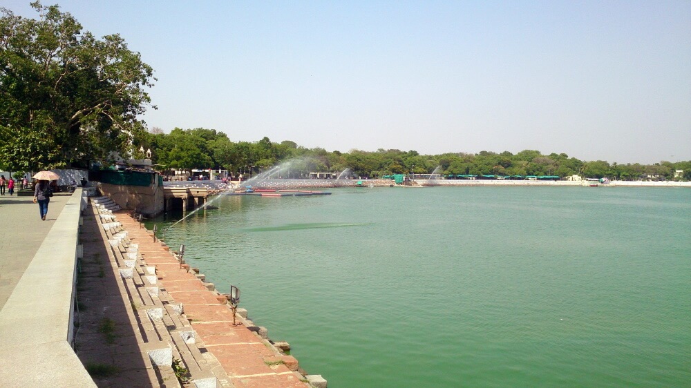
Photo: Creative Commons
Deeper problem
Before expanding, the municipal corporation would have to assess its reach and coverage of the city. It became apparent, in a recent study by Ravnish Kaur and Kshama Gupta of the Indian Institute of Remote Sensing, that the current drainage network in Ahmedabad caters to only 55 percent of the city and waterlogging was seen in areas served by stormwater drains due to insufficient capacity to carry it away. How can the rainwater be expected to find its way out of the city?
Fixing the stormwater drainage network and constructing with respect to natural water channels are critical for the future, given that Ahmedabad is projected to be a megacity in the next few years. The city’s population rose nearly four times from 15 lakh in 1971 to 55 lakh in 2011. The rapid urbanisation has resulted in increased land use and landfilling of waterbodies or natural areas, which has led to as much as 40 percent of the average annual rainfall flowing as surface run-off.
The Blue-Green Infrastructure is one of the ideas to move forward with so that more lakes, gardens, and open spaces are integrated with the existing built infrastructure. Researchers like Kaur and Gupta recommend that existing gardens and lakes can act as natural basins to retain rainwater while the excess water can finally be discharged into the Sabarmati River. The Blue-Green Infrastructure can be integrated across barren surfaces and road networks too which account for nearly 43 per cent of the city’s area.
Every flood brings out the same stories. What is needed now is for the municipal corporation, collaborating with planners and environmentalists, to find ways to integrate the green and blue into the built form of Ahmedabad.
Darshan Desai, a veteran Ahmedabad-based journalist, is currently the editor of Development News Network (DNN). He has written extensively on politics and policy in Gujarat and Uttar Pradesh for over 35 years.
Cover photo: Damayantee Dhar
There is 1 comment
This is a very interesting read. Have shared with others in my university for possible inclusion in our courses on Water and on Neighborhoods.