The Ghodbunder Road connecting Borivali suburb of Mumbai to Thane is an emblem of what lies ahead for the cities. Once a rickety and forgotten back road used mostly by goods vehicles, it passed through habitable parts of the Sanjay Gandhi National Park showing the forest in the cities. The serene stretch of the journey that I travelled daily for five years while studying for a degree in architecture is now filled with construction boulders, dust and JCBs as concretisation takes over the green. Ghodbunder Road is, to put it succinctly, a nightmare with hundreds of buildings, dug up roads, gridlocked traffic, and disappearing green.
To make things worse, a 14-lane corridor has been proposed.[1] With the Thane creek flowing along one side of the road, this means encroaching deeper into the forest. Several metro lines have been proposed to slither over Thane including the Thane Circular Metro, Mumbai Metro Line 4 which recently underwent its trial run[2] and Line 5 which have changed the colour palette here from greens to greys.
An hour’s journey and the red bus drops me off outside the gates of the SGNP in Borivali East. Known as Mumbai’s lungspace, this is a 106-square kilometre forest, about 30 times larger than New York’s 3.41 square kilometre Central Park and 100 times larger than London’s 1.4 square kilometre Hyde Park. Before it was named Sanjay Gandhi National Park in 1981, it was simply known as the Borivali National Park from 1968, and before that, Krishnagiri National Park.
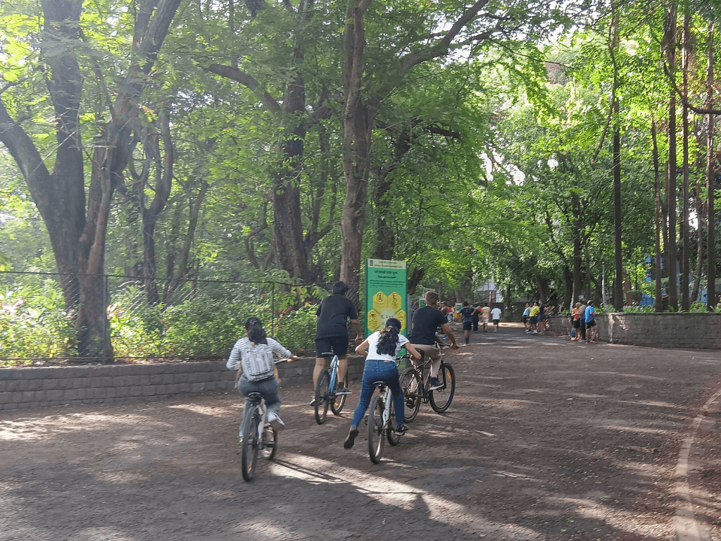
The ticket window is crowded with cyclists, nature lovers, morning walkers, and loiterers with friends. At Rs 103 a head, it leaves the green out of reach of daily wagers. Amrita Bhattacharjee, committed environmentalist and founder of the Aarey Conservation Group, joins me on this walk for Question of Cities and, together, we take in the soft morning sun as we wait for Dr Sashirekha Sureshkumar, botanist, tree expert and retired Head of Botany department, Mithibai College, to join us. We will walk in a space that across its expanse houses leopards, 300 bird species, 43 mammal species, around 150 butterfly species and several reptiles, amphibians and invertebrates – the only protected forest in the world this close to two cities.

The new national park
Our reason to walk-and-talk through the SGNP on a Sunday morning was a quest to understand what the draft zonal master plan can do to the forest. When the BMC released the plan[3] for the eco-sensitive zone of SGNP on September 10, it stirred up things. There was criticism and resistance. How could there not be? It proposed construction of various facilities and infrastructure, including for eco-tourism, in the eco-sensitive zones 1 and 2, leaving the third zone relatively untouched.
The eco-sensitive zone is the buffer zone between the SGNP forest and the densely concretised cities. Why open it to commercial activities at all? Besides, the forest is not just an abode for wildlife, flora and fauna but also safeguards the lives and livelihoods of a number of Adivasis living in its padas (hamlets). Bhattacharjee explains: “The language they have used in the draft plan for activities allowed in the eco-sensitive zone 2 is very vague. Words like ‘general business’ can imply any kind of business. And this is within the forest.” We walk on.
Dr Sashirekha points out new saplings that have been planted on either side of the road with ‘SIDBI’ marked on the fencing supporting them. These were planted by 150 employees of Small Industries Development Bank of India (SIDBI) and Give me Trees Trust that came together to plant 100 saplings of 15 varieties last October. But with most saplings planted close to each other with little space to grow, we wonder how many of these will flourish or even become invasive species here.
The Jungli badam trees, a Giloy climber wrapped around a palm tree, and Ashoka trees with their tender pink baby leaves offer unexpected softness and surround us with their shade as we persist in identifying the naturally growing plants vis-a-vis the planted saplings. “Trees are a part of the community. You cannot plant one in isolation. It’s a family, where each member is just as important,” Dr Sashirekha remarks, as she tears a leaf and asks us to smell it, a familiar fragrance, Imli. We bite into the leaf.
The fruits from the palm trees that fall to the ground form clusters of new saplings on the ground, all along our trail. A fruiting tree takes around 10 years of care until it finally bears fruit; when it does, it offers between 10-15 bunches of the ice apple or tadgola annually. A few steps ahead, we spot Gliricidia Sepium or Mother of Cocoa, locally known as ‘Undirmaar’ (mouse killer) because of its poisonous leaves, bark and seeds, used by the Adivasis to fence their homes to keep rodents out.

As cyclists zoom past us and joggers take water breaks, Bhattacharjee pulls up the digital version of the plan.[4] It comprises three hill ranges, Yeoor Range, Tulsi Range and the Krishnagiri Upvan Range. According to the plan, the extent of the eco-sensitive zone is a total area of 59.45 square kilometres.
The plan marks out the zones in three colours –- brown for ESZ1 as the development zone, light green for ESZ2 which is where regulated development will happen, and dark green for ESZ3 tagged as the ecologically fragile zone.[5] The ESZ3 with the highest density of vegetation and ecological preserves is the protected area while ESZ1 and 2 – still forest areas – will be open for construction activities. These are human-made distinctions; in reality, it’s all forest.
How do these boundaries get defined, do plants and animals know how to follow such boundaries? How much construction is too much construction for the forest to bear? Bhattacharjee points out the residential buildings along the edge of the road we walk on; the cluster used to be slums, she says, and was redeveloped. Who asked the forest if massive construction was okay in this part?

Alongside this demarcation of zones is the confusion the plan makes between the Adivasis, original inhabitants here, and slum dwellers; the former are shown, deliberately or otherwise, as the latter. It lacked rigorous ground-mapping and was published only in English. “Where will the people go? Their livelihoods are here in the forest. They want to shift them to Aarey which is so many kilometers away and they will have to buy a ticket at the gate to enter the national park,” points out Bhattacharjee. The plan, we agree, is for the land, no one thought of the people.
Ahead of us is the check dam over the Dahisar River. Its promenade has joggers, tourists, and morning walkers taking in the view and fresh air. That’s thanks to the trees. Perched up on a branch of a Kadamb tree right before us, is a Cormorant, a water bird with wax on its feathers, probably drying itself after a catch in the water. A small flight of stairs leads down to the top of the checkdam forming a bridge over the river. On the other side, mangroves, Rain trees and Ashoka trees flank the river with birds like herons leaping into the water.
“The leaves of large trees like Rain Tree are in a precise arrangement, they make space for the leaves at the bottom to get enough sunlight, casting only a partial shadow on the leaves on the lower branches,” says Dr Sashirekha. We walk along the promenade wondering the outcome once this ESZ-2 area is flocked with commercial activities, as per the plan. The Putranjiva trees, usually planted on the sides of roads, provide us with shade till we reach the boating point.
As we turn from the Nature Interpretation Centre (NIC) building, the trees get denser and we see Adivasi women selling star fruit, watermelon, pineapple, cucumber, boiled corn, chana, nimbu paani and similar produce. Bhattacharjee says this is her lunch on many days when she is in the field. A pit stop at Vandana Tokre’s stall to grab some of these fruits leads to a conversation with her about the plan. She shares her and her community’s apprehensions about eviction despite having lived there for decades. If Tokre and others are shifted to Aarey, nearly 12 kilometres away, urban life will be a challenge.
“The movement needs to be stronger,” adds Bhattacharjee as she tells us about the Goregaon-Mulund Link Road (GMLR) project connecting the city’s western and eastern suburbs with twin tunnels. These pass under hamlets and forested areas of the SGNP; how their movement is able to stall it remains to be seen.

Activists and locals alike talk about discrepancies and the lack of site assessment. “The tar road and construction of the shed had already started in Aarey before our on-ground report. The authorities don’t wait for us to study the conditions in detail. Whatever happened in Aarey is history,” Dr Sashirekha reflects. She was a part of the Tree Authority Panel whose recommendations fell on deaf ears.[6]
The plan also fails to capture the reality on the ground which, she says, is “a large mapping gap.” The plan marks the north end of Vihar Lake in the Sanjay Gandhi National Park as ESZ-3 and south as ESZ-2. There seems to be a plan to monetise the entire area in the name of eco-tourism. This will destroy the forest land, cause pollution of the Vihar Lake water that supplies drinking water to Mumbai. In 2021-22, the construction work of the cycle track project led to the destruction of the hills and the catchment areas of the lake,” explains Bhattacharjee.
While the three parts of the forest – Borivali side, the Yeoor expanse, and Aarey – have their own demographics and topographies, the plan is a direct manipulation of their natural conditions. The Yeoor village, towards the Thane side of the SGNP, has eight Adivasi padas and numerous natural streams, but animals now forget their trails as boundary walls and fences around private properties are constructed. This fate perhaps awaits the wildlife in ESZ2
Amidst these conversations and deliberations, we enter an Adivasi pada that sits organically and quietly in the forest landscape, a world starkly different from the chaos of a metropolis outside. We find a rhythm that feels older than the city – smoke rising gently from wood fires, children’s laughter echoing through the foliage, the sound of pestle meeting grain, birds answering from the canopy, all of it folds into the quiet harmony between people and forest. And the geometric shapes of the Warli folk art capture it all.
To walk here and find silence is to realise that the people and nature are harmoniously one, or are meant to be so. The plan does not recognise this or that the entire SGNP, including its eco-sensitive buffer zone, offers quiet functional harmony to Mumbai and Thane. Nature has endured here but for how long, I wonder.
Nikeita Saraf, a Thane-based architect and urban practitioner, works as illustrator and writer with Question of Cities. Through her academic years at School of Environment and Architecture, and later as Urban Fellow at the Indian Institute of Human Settlements (IIHS), she tried to explore, in various forms, the web of relationships which create space and form the essence of storytelling. Her interests in storytelling and narrative mapping stem from how people map their worlds and she explores this through her everyday practice of illustrating and archiving.
Photos: Nikeita Saraf