‘What makes a regime distinctive,
is where it draws the line between economy and nature,
and how it operationalises that division.’
-Nancy Fraser
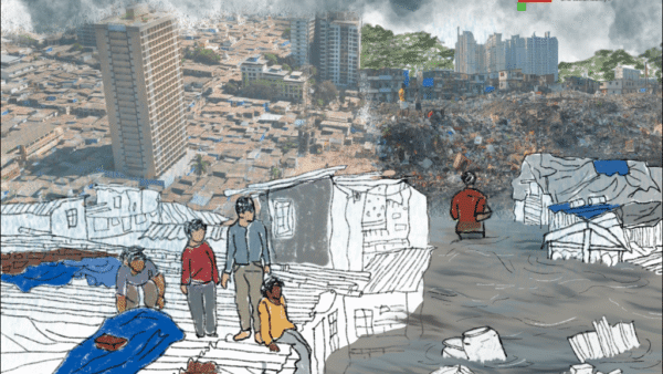
Urban environments play an active role in causing and intensifying Climate Change phenomena such as increasing temperature, solar radiation, loss of habitat, ecological diversity, and shifting weather patterns. Urban planning and policy that enables this is primarily oriented towards economic growth, and employs drastic changes to the natural environment as the means to achieve this growth. The immediate effects are seen in Urban Heat Island effect, heat waves, reduced vegetation cover, degraded soil quality, air and water pollution, heavy and unpredictable flooding. Urbanisation brings profound physical, environmental, socio-cultural, economic and political changes sharing a reciprocal relation to disaster risk and vulnerabilities due to Climate Change.
The rapid and dramatic transformation of the western periphery of Hyderabad, cast in the image of a ‘global city’, offers a remarkable window into this. The creation of a new suburb, branded and marketed as ‘Neopolis’, adjoining the financial district and the IT/ITES hub in Gachibowli, is a case study in the relationship between urban development practices and the natural environment. The knowledge and evidence of the effects of Climate Change long predate these policies and practices of economic growth. This implies an inherent logic embedded in them that make them antithetical to climate resilience.
This essay argues, in two parts, that a deeper understanding of the relationship between cities and the climate crisis leads to the crucial role played by urban planning and policies which are designed to exacerbate – rather than mitigate – Climate Change. A solution lies in rectifying the planning and policy frameworks. It also argues that these practices are not arbitrary or ad hoc occurrences but determined by the neo-liberal logic of unlimited economic growth and financialisation which currently dominate urban development in India.
Neopolis and sub-cities
On August 3, the Hyderabad Metropolitan Development Authority (HMDA) conducted a digital auction of plots setting a new record for land prices sold at Rs 100 crore per acre. To the government, this price implied the desired progress of urban development justifying land as a critical resource, IT and real estate industries as core segments of the city’s economy, and Hyderabad as the preferred destination for investments and offices of national/international corporations
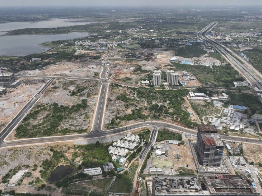
Christened Neopolis, the hitherto farming site is a 533-acre ‘greenfield’ development near the Osman Sagar reservoir. Projected as yet another central business district, it is planned for an overwhelming 90 million square feet workspace with employment opportunities for up to seven lakh people within the next decade. The development of Neopolis, at a strategic location, emphasises the provision of public infrastructure, social amenities and cultural institutions. Its commercial and real estate potential is projected to rise because of the proximity to developed parts of the city.
It is also promoted as an exemplar of ‘sustainable development’ planned around the ‘walk to work’ concept. However, the relaxation of regulatory frameworks and suspending the existing planning system begin to complete its story. With unlimited Floor Space Index (FSI) and no limits to building height, the marketing of this ‘world-class city’ is with the explicit aim of attracting developers, investors, and corporate entities. This serves two purposes – directing the IT/ITES development towards southwestern periphery to increase surrounding land prices, and creating a dramatic skyline of a ‘global city’ driven by speculative urbanism.

Source: Cities and Climate Change, Harriet Buckeley
The current planning practice reveals a radical shift in urban development aligned to the neoliberal paradigm of the 1990s. The passage of the 74th Amendment Act reorganised urban local bodies and devolved power to municipalities. At the same time the ‘Andhra Pradesh Vision 2020’ identified a set of “growth engines” with an emphasis on the service sector, prioritising the development of IT-related services, biotechnology, tourism, logistics which called for high-quality urban infrastructure.[1]
The state government announced the first ICT (Information & Communications Technology) Policy in 1999 with incentives such as highly subsidised government land reserved for specific industries, zoning exemptions, land use conversion, uninterrupted power supply, tax breaks, registration refunds, and repeal of Urban Land Ceiling and Regulation Act of 1976 to allow industries to hold excess land for future land transactions. In order to create an ecosystem for ease of business, the single window for project approvals was set up. The oversimplified process led to mushrooming of industries around the periphery of Hyderabad.[2]
What began with the development of Gachibowli as the IT hub expanded into adjoining areas and, further, along the new international airport and its associated commercial or industrial zones. These zones surrounding the city have dedicated clusters such as aviation, pharmaceuticals, biotechnology, and IT – all connected by a 158 kilometre eight-lane high-speed, tolled highway called the Outer Ring Road.
The state thus came to occupy the role of a land broker for capital by appropriating land for private use and creating land banks, by redrawing the city’s boundaries and setting up new urban local bodies for governance.[3] At present, Hyderabad is governed by five different Master Plans.[4]

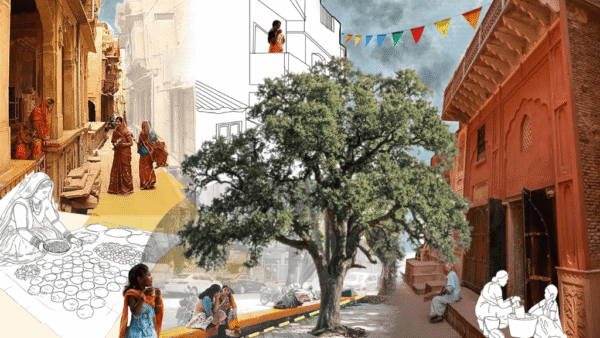
Illustration: Arshiya Syed
These plans assembled land parcels with mechanisms such as land pooling schemes, layout development plans, and subdivision or amalgamation of plots, simplifying building regulations and a flexible approach to construction. This was complemented by the digital self-certification system to acquire building permits, replacing the conventional practice of municipal representatives physically inspecting sites to ensure compliance with building codes and regulations.
The municipality lacks the resources, powers and political will to enforce master plans in their entirety unlike the special development area authorities which can issue permits for unregulated growth of certain areas and develop infrastructure to attract investments. In Hyderabad, such authorities were carved out for select areas with special planning controls and high levels of managerial input, and were combined to create the HMDA in 2008. While this leads to greater functional integration, it has also created a highly fragmented city.

Illustration: Arshiya Syed
Problems of new sub-cities
Neopolis, much like its predecessors, exemplifies the process by ‘which contemporary urbanisation in India creates variegated and uneven geographies, serving capital accumulation led and deepened by state policies.’[5] It is essential to understand the cause of proliferation of such new cities, and the effects of planning in the context of sustainable development and climate action. It enables an insight into the contradiction of the lived city as an engine of economic growth through infrastructure expansion, and as a site of social and economic breakdown exacerbated by Climate Change.
Environmental contradictions are ingrained in developments such as Neopolis. It necessitates change in land use from a complex combination of non-urban environments in the Deccan plateau such as farms, settlements, scrubland, pastures, wooded areas, lakes, streams, hills, rocky outcrops, into a series of standardised plots fit for auction. Modifications to natural vegetation have detrimental effects on the ecosystem’s ability to mitigate stormwater runoff, flooding, and absorption, and are also linked to an escalation in heat island effects.
Further, the commodification of land is achieved by coercive displacement of existing farmers, farmworkers, rural artisans, and tribespeople using laws like the Land Acquisition Act. The impact of land loss on the livelihood and economic well-being of rural communities is well-documented; 37 out of the 70 approved Special Economic Zones (SEZs) are located in peri-urban areas around Hyderabad.

Photo: Kulsum Nafisa
The marketing discourse about Neopolis focuses on the brand identity of the enclave, emphasising visual and sensory characteristics such as the skyline, highway interchanges, the presence of international brands as employers and providers of consumer goods, and its globally aspirational nature. Hyderabad is presented primarily as a site of cultural heritage for citizens of Neopolis to consume. While the marketing literature does mention proximity to workplaces and the presence of public transportation, these are neither allowed in any housing policy or regulation, nor in the creation of enabling infrastructure.
The built environment of Neopolis is mainly tall residential buildings, served by car-centric infrastructure, and other resource-intensive facilities. Exceptionally fertile farmland is being transformed into a series of land banks, while the topography of the land is being altered to create a suitably flat and uniform terrain for roads and utilities. In the process, the rocky hills and scrubland that absorbed and regulated water flow, and sustained a diverse ecosystem, are erased as they are perceived as obstacles to ‘development’.[6]
This research found that Neopolis is, therefore, not an organic growth of the city’s spread and density, nor is it a planned city driven by public or state imperatives such as India’s previous planned cities; instead, its establishment and growth are the result of purely profit-driven motives with the economic logic of real estate speculation overriding other motivation. The influence of neoliberal logic of place-making can be clearly seen as the driving force here.
The vast scale of destruction of the Deccan landscape exemplifies the change in planning – from a creative practice to a fundamentally destructive process driven by technological advancements and commoditisation of architecture now fully subsumed within the neo-liberal logic of capital. This involves the notion of efficiencies of scale in the assembly line production of buildings and urban design, in turn leading to the holy grail of increasing profit accumulation. While Neopolis claims to be a sustainable development, it is anything but that.
Such exercise of power by displacement of people to redraw city’s boundaries,[7] sweeping away environmental concerns through administrative fiat[8] and physically flattening the landscape with earth movers, explosives, and a vast cheap manual labour drawn from the northern states, all demonstrate the critical role of the neo-liberal state in planning, and by extension, in altering the forms of the physical landscape and ecology. These actions are only possible if the state sees its role primarily as an enabler of capital, and only indirectly as a mechanism for public welfare. For any meaningful understanding of climate action policies and projects, it is therefore crucial to examine the role of the state in crafting urban policy and planning practices.

Photo: Kulsum Nafisa
The building of new sub-cities, such as Neopolis, create a narrative that they solve a variety of urban problems while promoting a place and shaping development by unregulated market-oriented growth. The transformation is made possible by appropriating land as an asset for financial accumulation and commodification, rather than as a fundamental resource to constructing affordable housing, and markets, and industries to benefit the people.
While new ‘cities’ contribute to economic growth and improved living conditions for some people, their negative consequences include social exclusion, spatial fragmentation, threats to democratic process, and environmental concerns such as Climate Change.[9] There is an absence of recognition of risk embedded in the geomorphology of the city, and limited comprehension of how urbanisation contributes to Climate Change. The entrepreneurial approach to planning and governance continues to neglect climate mitigation even though economic growth is contingent upon the resilience of urban areas.[10]
Climate signals for Hyderabad
Hyderabad is the fourth most populated city with an aggregate population of 10.2 million, and second largest metropolitan area covering 7,257 square kilometres. Hyderabad occupies only 0.6 percent of the total land in Telangana – which is 46.8 percent urbanised – yet houses 20 percent of its population and contributes to over 80 percent of the state’s GDP. In comparison, agriculture contributes 16 percent but with 59.6 percent people depending on it. The city is profoundly affected by climate-related events, its risks heightened as in any metropolitan area.
Hyderabad has experienced a number of extreme weather events in recent years including periodic flooding,[11][12] prolonged heat waves with successive hottest years,[13][14]
and extended droughts[15] affecting people’s health and livelihoods. It was only in early 2020 that the Greater Hyderabad Municipal Corporation reserved 10 percent of its finance for adaptation to ‘global warming and climate change’ under its Green Budget. Hyderabad is the second city in India to establish a specialised disaster response unit, the Directorate of Enforcement Vigilance and Disaster Management (EVDM), tasked with rescue and relief efforts in the aftermath of a disaster.
Hyderabad falls in a semi-arid climatic zone with a predominantly hot and dry climate, and average summer temperatures between 34-39 degrees Celsius. It receives 80 percent of its annual rainfall from the southwest monsoon with an annual average precipitation of 860 mm. It has experienced devastating floods in the past. The most disastrous was in 1908 when low-lying areas up to a height of 3.3 meters were inundated and the river Musi broke its banks, claiming nearly 15,000 lives and destroying over 19,000 homes. A flood management and drainage proposal for the city was made by Sir M Visvesvaraya leading to the construction of two upstream storage reservoirs – Osman Sagar in 1920 and Himayat Sagar in 1927.[16]

Photo: Courtesy The Illustrated London News
Though Hyderabad has not experienced such high intensity rainfall since, the twin reservoirs have saved Hyderabad from at least six major flooding events between 1908 and early 2000s. In August 2000, rainfall of 241.5mm a day inundated several areas under 2-4 meters of water. Eight years later, the city received yet another heavy rainfall of 137 mm a day inundating low-lying areas. The most recent flooding was in October 2020, which saw rainfall of 192 mm[17] affecting, over a few weeks, as many as 1,80,000 people and causing an estimated loss of Rs 5,000 crore.[18]
It led to the inundation of several low-lying areas, breaching of lake bunds, collapse of buildings, and flooding of river causeways. The catastrophic flood of 1908 and subsequent modernisation of Hyderabad left a profound impression in the collective memory of the city. However, current heat waves and extreme rainfall events have a dispersed and insidious impact, treated as isolated incidents and individualised experiences. This leads to their absence from public discourse and makes it harder to grasp the extent of their consequences.

The city has witnessed temperature variations and successive hottest years, with the summer temperature reaching as high as 47.6 degrees Celsius in 2015, and 44.4 in 2020. This trend corresponds with the unprecedented increase in temperatures in India in recent years.[19] Climate models have confirmed that average, minimum and maximum temperatures are expected to rise in Telangana. Coupled with 40 percent humidity in summer months, the 40 degrees Celsius reaches a dangerous heat index of 48 degrees Celsius (‘feels like temperature’) causing severe heat stress for people.

The frequency and duration of severe heat waves increased significantly from the 1990s. The undivided state of Andhra Pradesh reported 3,054 deaths due to a heatwave in 2003.[20] When a severe heatwave struck India in 2015, Telangana had the second highest death rate of 585.[21]
The Urban Heat Island effect in Hyderabad exhibits significant variations with an annual average increase of 1.25 degrees Celsius. This phenomenon occurs when urban areas have higher air and surface temperatures compared to their surroundings due to high-density built-up areas. There is a notable rise in minimum temperature and decrease in maximum temperature; this warming is high during night time. It disrupts the radiative cooling process, making night time conditions less comfortable and affecting people’s health.[22]
The shifts in local weather patterns over the past two decades provide a clear indication of long-term trends in the city’s climate, supported by scientific and archival data. These changes are considered among the ‘climate signals’ for Hyderabad that represent larger shifts attributed to Climate Change.[23]
End of part 1
Arshiya Syed is the founder of an architecture and urban design firm Studio Maqam in Hyderabad, Deccan. She is a graduate from the School of Planning and Architecture, New Delhi, and an Urban Fellow from the Indian Institute of Human Settlements in Bangalore. She is also a visiting faculty conducting urban design and housing studio in architecture schools.
This is the first part of a series supported by the QoC-CANSA Fellowship to report on Climate Change and cities in four nations of South Asia.
Cover photo: Neopolis layout in Kokapet with Outer Ring Road (right) and Osman Sagar reservoir (left) by HMDA