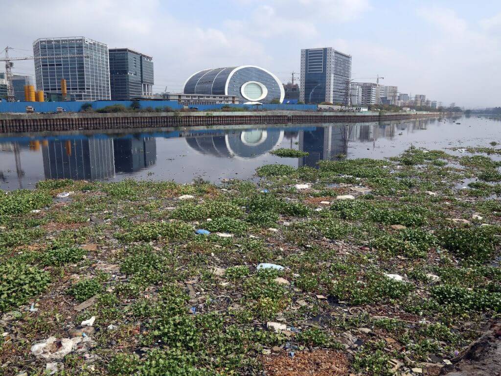
From the edge of Dharavi with the mighty Arabian Sea to the left, the swanky buildings of the Bandra Kurla Complex (BKC) look like a sales brochure come to life – except for the stretch of filthy and smelly water that lies in between them. This is, for all purposes, the infamous Mithi river of Mumbai which, 18 years after it came into sharp public consciousness, still looks a neglected and stinking drain with untreated garbage floating on the water, its colour bordering on black, and its width at the BKC narrower than ever before.
Mumbai has been flooded many times since that fateful day of July 26, 2005 when its suburbs received 940 mm of rain in 24 hours taking nearly 400 lives and destroying property worth crores. Almost every monsoon has meant floods since then; every flood brings back the question. Will Mithi overrun Mumbai again? The 17.84 kilometres long river is a confluence of discharges from Vihar and Powai lakes, passes through some of the most densely-inhabited areas and commercial hubs of the city, before reaching the Mahim Bay to empty into the Arabian sea.
Eighteen years and at least ten committee reports after the July 2005 flood, some work has been done on the Mithi along the recommended lines including widening and deepening the river, annual desilting, construction of retaining walls and so on, but a lot remains to be done to restore the river back to its peak health, to give its space back. The work done is more like a patchwork project; what is needed is a vision and plan to ecologically restore it and comprehensively integrate it into Mumbai’s development so that the city’s natural water channels are restored.

Its water is still brackish, green hydrangea blooms on its surface, there are towering dumps of construction and domestic waste, and the stench is anything but that of a river. Even in the work carried out, serious questions have been raised about the retaining walls and the sustainability of the deepening. A Supreme Court-appointed panel, conducting a status check of the work done till 2018, made wide-ranging recommendations about these and other aspects, and called for a comprehensive Mithi River Eco-restoration Plan with this unequivocal line: “we wish Mithi River becomes the pride of the city (rather) than its liability”. This, surely, is some way away.
Monsoons and the Mithi
July 2023 was the wettest July ever recorded in Mumbai with a staggering 1,557.8 mm of rainfall through most of the month, according to the India Meteorological Department. The previous high for July was three years ago with 1,502 mm of rainfall. There were localised floods in areas that the Mithi passes by but the water receded perhaps because the high rainfall did not coincide with the high tide which typically prevents the rain water from flowing out.

In 2019 though, the situation had turned alarming in these areas. In early August, after a day of incessant rain, the Mithi flowed four metres high – more than half a metre above its danger mark – which disrupted suburban train services on the main line between Chhatrapati Shivaji Maharaj Terminus and Thane, flooded roads and homes, submerged vehicles and pushed authorities into evacuating hundreds of people living in the worst-hit areas along the river such as Kurla, Sion, Bandra and Powai.[1]
Mumbai cannot depend on the chance that high rainfall and high tide will not coincide. The Mithi was, and continues to be, a major channel of the city’s drainage network during the monsoon; its floodplain remains vulnerable to inundation whenever heavy rainfall and high tide do coincide. With Climate Change contributing to extremely high rainfall in short periods of time, the once-in-50-years rain may well happen more frequently. Are the authorities overseeing the Mithi – among them the Brihanmumbai Municipal Corporation (BMC) and the Mumbai Metropolitan Region Development Authority (MMRDA) and the Mithi River Development and Protection Authority (MRDPA) which functions as a coordinating authority between different agencies – confident that the river basin areas will not see a massive flood? The short answer to this is in negative.
This is not because the authorities are unaware of what steps need to be taken to keep the Mithi – and other rivers in the city such as Poisar, Dahisar and Oshiwara – in a healthy flowing condition. The measures have been outlined, detailed, and repeated in reports since July 2005 – the first among these being the Chitale Committee fact finding report presented the very next year – but what is missing since then is the political will to implement them, the administrative sense of purpose, and importantly macro vision for the Mithi and its place in Mumbai.

Photo: Imtiyaz Shaikh
Piecemeal work replaces ecological vision
The desilting and deepening work has been handled by different agencies in sections of the river; removing encroachments with adequate rehabilitation of people remains a politically-sensitive issue. Years after, large tracts of informal settlements and industries are still encroaching on the river banks, sewage treatment plants are nearly absent, solid waste continues to be dumped especially near the settlements. The periodic pre-monsoon action against activities such as washing oil and chemical drums in the river, throwing hazardous waste and animal waste from cattle sheds, cleaning work of scrap dealers and others who dump sludge oil and effluents has yielded little.
This January, the BMC initiated Mithi’s rejuvenation by way of filtration of 80 lakh litres of water and set up a sewage treatment plant near Powai Garden. Using ‘roboholes’, an automated system to remove waste from water and treat it in stages, the BMC hopes to restore the riverine ecology.[2]
Another phase of the Mithi Project has the BMC sewage department planning to install 27 floodgates or pumping stations at the outfalls of the Mithi into the sea besides sewer interceptions-diversions at various outfalls and nallahs into nearest municipal sewer drains, which could help when heavy rainfall coincides with high tides.[3]
In the absence of the authorities undertaking comprehensive restoration, the annual discussions about it are “like flogging a dead hound,” D. Stalin of Vanashakti remarked to Question of Cities. The environmental advocacy group took the Mithi issue to the National Green Tribunal and later to the Supreme Court. “Planning bodies like BMC and MMRDA are giving out land near the river for construction. If this continues, not even a square feet space will be left next to the river…they are not concerned about the river, they seem to be in a race about who will destroy it better. If the river is restored to its original character, then this vast land will become unavailable for construction,” he said.
Construction over river – twice
Stalin’s allusion is to the Bandra Kurla Complex, which literally sits on the Mithi. Over the last decade and half, the BKC has become Mumbai’s most-sought after and expensive real estate for commercial, residential and recreation purposes. The brackish Mithi forms the backdrop to many plush offices and swanky homes here, but the BKC is itself the river’s problem.


The maps show clearly that the BKC has narrowed down the river at one of its crucial and wide junctures, before it empties out into the Mahim bay, jeopardising the fragile ecosystem of mangroves too. “The major problem of flooding is due to reclamation of land, 620 hectares, for the Bandra Kurla Complex and due to the bottleneck forming at the confluence of the non-widened bridges at the downstream side of the Mithi River system,” the SC-appointed panel of experts from IIT-Bombay, NEERI and civil society had unequivocally pointed out. The panel, therefore, recommended that all the bridges be widened according to the suggestions made by various committees adding that “the suggested widths near the confluence are of utmost importance”.
The landfilling and construction, which have encroached into the river, are set to worsen as Dharavi, across the Mithi, undergoes a massive redevelopment over the next decade with more construction, high densities, and the likelihood of connectors constructed across the river to link the two areas. Past experience has shown that ecologically unsound kinds of human interventions, including indiscriminate landfilling and construction, can cause more problems than they solve.
Decades before the BKC was constructed, the Mithi’s course was disrupted for Mumbai’s airport. In 2005, the airport and areas around it were among the most severely flooded. As the Chitale Committee pointed out, “…the semi-circular structure of the Chhatrapati Shivaji Maharaj International Airport at Sahar appears to have been placed within the area of natural bend of the Mithi River…the river has been bent several times by the extension of runway (already in place) and taxi bay (currently being constructed)…Also, the river islands were cut and levelled and two water bodies (on runway) filled and reclaimed by the Airport Authority. Clearly, over the years, the river course seems to have been narrowed and guided or trained significantly”.
An area where work has been done since 2005 is the widening and deepening of the Mithi which, by accounts available, has led to an increase in the river’s carrying capacity – but not sufficiently. Reports of the MRDPA state that “the increase in the conveyance capacity is more than three times compared to the conditions in 2005 (and) the basin capacity, which is important for holding a part of the floodwaters, has more than doubled”.
However, the SC-appointed panel pointed out that the capacity should be increased “for safe and sufficient 100-year rainfall return period coinciding with extreme high tide” as on July 26, 2005. Importantly, it questioned the claim of capacity increase given that the width of the river had been reduced due to real estate development allowed as well as the retaining walls constructed which it termed “indiscriminate”.
Retaining walls – a problem, not solution
The construction of retaining walls along the Mithi is controversial. Undertaken by both the BMC and MMRDA on stretches they control, the retaining walls came in for the harshest criticism by the SC-appointed panel. The walls are “not as per riverine methodology. Also, the proposed width of the river has been reduced,” it pointed out besides referring to the impervious nature which does not allow water absorption into the ground.
Importantly, the field visit by the panel showed that the retaining walls had been built on both sides even in forest areas like Aarey “thus preventing the interaction of river with the forest itself” which would impact the river’s ecology and lead to environmental problems. The walls have not been constructed in a manner suitable to an urban river, the report stated adding that they were made “without considering riverine hydrology, environmental and flooding aspects…made above the ground, up to three metres in many locations, without giving any scope for water to flow to and fro the river during high rainfall conditions…which may lead to localised flooding in areas adjacent to the retaining walls”.

Photo: Imtiyaz Shaikh
Localised flooding has become a part of Mumbai’s rainfall experience in recent years. The areas that flood with even moderate rain are the ones straddling the Mithi. Ideally, the walls should be modified or reconsidered. The report called for specific walls to be broken and redesigned. The walls do not necessarily mean better flood control; they may enhance flood vulnerability in certain places.
Besides this, the immediate provision of a minimum 15 metres on both sides of the river as buffer zone along with 50 metres No Development Zone reservation would help act floodplain during heavy rainfall; service roads on both sides would make the river accessible to people and allow better reach, the panel recommended. Little has been done on these fronts. Also, the pollution level of the Mithi remains high; in fact, it showed an increase when compared to data in the 2015 study done by the IIT-NEERI. Till the sewage network is secured along the Mithi, the river cannot be restored to health and it cannot function as the city’s natural water drainage during rainfall.
Aslam Saiyad, a photographer and researcher who documented Mumbai’s rivers, told Question of Cities that the concretisation around the river banks has left no place for its flow. “If we have to change anything, we have to remove the constructions around the river and relocate the city,” he pointed out, “These ‘floods’ are not actual floods but just the river taking its course. We have to accept that.”
As others have, Saiyid too referred to Aarey, a major floodplain of the Mithi, which is steadily being constructed upon leaving no place for the river. “It is going to cause inundation in Andheri and Kurla,” he said. While allowing construction in Aarey, the BMC has initiated projects such as constructing a weir in Jogeshwari and holding ponds in Aarey to help the Mithi; measuring scales and flow meters have been installed to track the water rise in the river. Other flood preparedness work has been done in Mumbai over the past few years.
Yet, without comprehensively and ecologically restoring Mithi, Mumbai cannot be safe from floods. Even with it, Mumbai is vulnerable; without it, doomed.
Jashvitha Dhagey is a multimedia journalist and researcher. She developed a deep interest in the way cities function, watching Mumbai at work. She holds a post-graduate diploma in Social Communications Media from Sophia Polytechnic. She loves to watch and chronicle the multiple interactions between people, between people and power, and society and media.
Shivani Dave is an architect, writer and illustrator interested in exploring the intersection of architecture and social sciences. After graduating in architecture from Mumbai, and in media from the London School of Journalism, she is applying the fundamentals of architectural research and writing within urban contexts to develop phenomenological ideas about life in cities.
Cover photo: Imtiyaz Shaikh