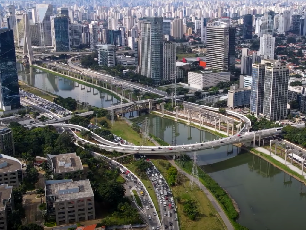
Tietê River is the largest river in São Paulo, termed as open sewer by many. Although São Paulo is pictured as a metropolis teeming with towers atop a robust topography, significant portions of the city sit along the Pinheiros and Tietê rivers, writes architect Felipe Correa in his book São Paulo: A Graphic Biography. Published in 2018, the book details the changes in urban fabric as the population multiplied. Correa, currently the Director of the Urban Prosperity Institute, and formerly the Chair of Architecture at the University of Virginia’s School of Architecture, and Director of the Urban Design Programme at the Harvard Graduate School of Design, says a lot of his work “focuses on looking at cities through their relationship to rivers”. He draws parallels between Mumbai and São Paulo in this context.
Tell us a bit about your book on São Paulo and why you wrote it.
A lot of the work that I do, primarily through my firm Somatic Collaborative, looks at the intersection of architecture, urbanism, and infrastructure. Some of the projects we do are direct design commissions, others are applied research projects, where we look at the history of urban form of cities, how they need to learn from that history to transform certain parts and portions of the city in the future.
That’s where a project like São Paulo comes in. It was supported by the Haddad Foundation in São Paulo. It’s about how a metropolitan region of 20-25 million people, with the largest amount of former industrial inner-city land in the world, could rethink its relationship with the river in a context where industry, which drove urbanisation along the river, is no longer present as the city moved to service-based economies. This was the initial premise. Our interest also came from trying to understand how a city that in the 1850s had a population of about 30,000 is a metropolitan region today with over 25 million. What is the history of the urban form in the past 100 years that allowed São Paulo to become São Paulo?
What factors led to the disconnect between the river and the city or the people?
This is prominent in many cities across the world. Throughout the 20th century, the river was seen as a purely utilitarian entity. It was put to work for the economic development of the city but was never a protagonist of the city. Through a famous project in São Paulo called the Rectification Project, they canalised the river to be able to generate dry land adjacent to it for industries — not that different from the islands in the archipelago of Bombay which were landfilled to create dry land for urban development. In many ways, that’s a late 19th or early 20th century vision in which rivers were put to work. Today, we need to move beyond that and ask ourselves, what is the role that rivers can play as active participants in the city.
How can this be done? What does your book prescribe for São Paulo to reconnect with its rivers?
That is what we focus on in the book’s last chapter in what we call an ‘evolutionary plan’ for São Paulo. Our argument is that now that the river is no longer the epicentre of industry, there is an incredible opportunity to turn it into a new civic landscape that gives the river back its space. There are strategies we recommend for the river to expand its footprint and, in doing that, create a new waterfront.
This, on the one hand, gives a new civic identity to that part of the city, and on the other hand, serves as a sponge to manage significant stormwater runoff that the city can no longer handle through mechanical means or conventional 20th century forms of drainage. The new role of the river should be dual — new high quality public space and to help deal with stormwater management in the context of environmental uncertainty and climate change.
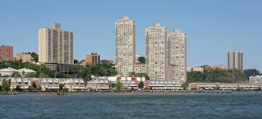
Photo: Wikimedia Commons
You have been to Mumbai and studied its rivers including the Mithi. What’s your understanding?
Mumbai is one of my favourite cities in India. There are many important parallels between Mumbai and São Paulo. The Mithi River, like the Tietê River in São Paulo, was heavily transformed for the sake of industry and very fast-paced urbanisation. Obviously, today, the Mithi is an incredibly complex system of human and non-human entities that are co-authoring its form and its operation.
The key question for me is how does Mumbai, as a city, want to frame the role of the river for the next decades, if not centuries? Now is the right moment to begin looking more carefully at the Mithi’s future. The 2005 floods, I believe, spearheaded a lot of initiatives in the transformation of the river but a lot of them have been piecemeal. From my perspective, what a city like Mumbai needs is a study that carefully frames the river in a more aspirational manner. What do the people of Mumbai want from its river in the next few decades or century?
Your book mentions “restraining the rivers for the sake of urbanisation”. How was this done?
This was very, very prominent. Cities were doing this. In the late 19th, early 20th century, it was believed that investment in hydrological infrastructure could tame rivers and put them to work for the sake of economic development. Today, we have seen that rivers have a life and momentum of their own, and we need to understand how rivers work and allow them to coexist with urbanisation. That’s a very different mindset than putting them to work. That’s what we advocated for São Paulo and for other cities – that the river has to be given its space and its cycles have to be allowed to coexist with the cycles of the city.
How would you explain this in the context of Mumbai and its rivers, especially the Mithi which is now the site of massive land-use and construction?
The Mithi River and its edges are some of the most densely populated river edges in the world, which means that you have not only a lot of constituencies that shape the form and culture of the river’s edge, but also a lot of informal activities. This creates a very complex situation for comprehensive urban visions to restore the river. For me, there are a couple of important things when looking at rivers at that scale.
First is a very clear study and understanding of what constitutes the river’s edge today. The ecologies of the river are way beyond the traditional river boundaries that we draw in a map. An initial study of Mumbai of these boundaries and ecologies would be extremely useful. Then, there are ways in which you can prioritise pilot projects that might help rethink the river from a series of perspectives.
One, in terms of cleaning the river and dealing with questions of water treatment which are key. Two, making the river an important public and civic space within the city in a more consistent manner. If one looks at the river, there are many spaces that are already very important to citizens of Mumbai. But this can be done in a more systematic manner. And three, find ways in which new real estate development can align well with a larger public and civic infrastructure along the river.
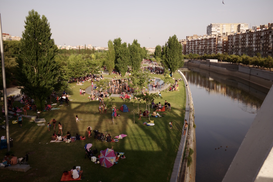
Photo: Wikimedia Commons
Have similar solutions been done in São Paulo?
Yes, but many have happened in a fragmented manner. And that’s the tricky part. At the end of the day, any project that restructures a waterfront is going to have to be built in fragments. What is the sequence of these pieces and how that builds something greater than the sum of its parts is one of the key design challenges. There are many cities that have transformed their rivers. The Madrid Rio project is a great example of a city where the river was not at the forefront of people’s minds but with an incredible landscape operation, they were able to make it a central space within the city. Seoul in South Korea has also brought back secondary and tertiary rivers as important public spaces. In Mumbai, it’s incredibly more challenging because of the city’s density.
Given Mumbai’s topography and relationship to water, how can it strengthen this relationship in times of climate change?
An intervention along the river that rethinks a broader hydrological project for the city is essential. One that brings together water management with urban development and civic aspiration. Once again, it’s not just the river, but a series of networks, smaller nullahs, and secondary rivers that make up the basin. The city needs a project like that to be able to confront the climatic challenges in the next 50 years, 50 to 100 years, because it can help mitigate stormwater runoff. It can help accommodate tidal surges during massive floods. It can also help educate a larger audience about the relationship between cities, water, public space, public health. Holistically, the project can bring to the table many aspects that are not just about a new waterfront park, but how we redefine the relationship of the city to water.
“Viewed through unidentified snapshots, São Paulo could perhaps be mistaken for a greater number of cities than any other in the world. From certain angles, it might look like New York; from others, New Delhi,” you write in your book. The Yamuna floodplains in New Delhi too have seen massive encroachments.
How can the floodplains be restored?
In a different context, but with a similar approach to what we were discussing about Mumbai, I think New Delhi has to come together and collectively decide the river’s role in the city. Maybe, New Delhi has an advantage in relation to Mumbai, which is that the amount of industry that was developed along the river was not as extreme. The Yamuna has a lot of issues with contamination. It also has an important aspect about the role of the river and religion. So, there’s a larger cultural dimension about the Yamuna that has to be studied to then be able to rethink what the future of the river in the city will be. Ultimately, I believe the Yamuna River could play a much more pivotal role in the capital’s urban identity.
What are the main problems plaguing rivers in cities and what examples are there of a healthy city-river relationship?
Cities always have challenges but they also offer incredible lessons. As architects, as urbanists, as concerned citizens, we need to not only focus on the problems and challenges of the cities we live in but also understand their history. Within that history, we find powerful lessons and projects that have helped us mitigate those challenges. As time changes, we need to update those lessons but they give us optimism about the future of the city. And if you really think about it, cities are always a place of optimism. Nobody migrates to cities thinking it’s going to be worse than the place that they are leaving, right?
I always believe that life in cities is better. I’m a huge advocate of density. To answer the question more specifically, those challenges have to be examined in a case-by-case situation, city-by-city. The challenges of New Delhi are not going to be the same as those in Mumbai. They might share certain baselines but the stakeholders, climate, soils, and relationship to water is going to be different. A part of our role as architects and urbanists is to be able to draw and visualise those relationships so that we can have an informed conversation about how to move forward.
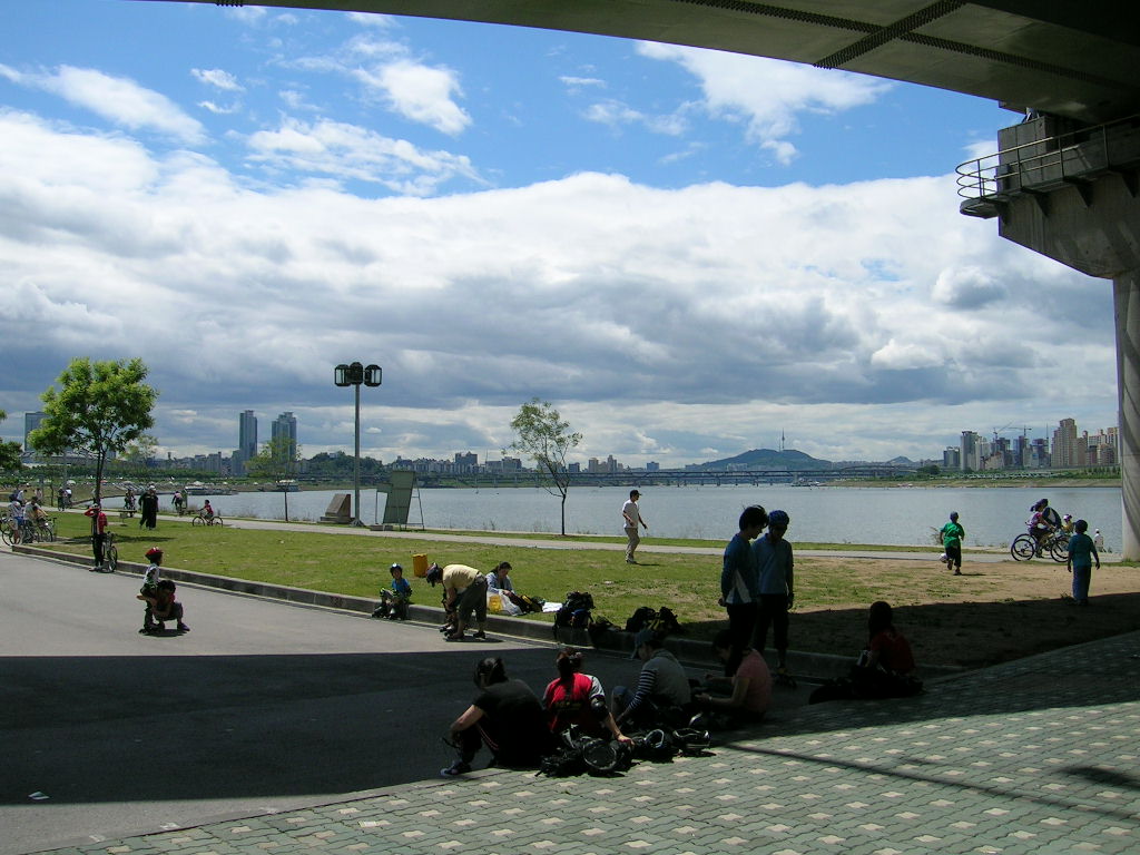
Photo: Wikimedia Commons
Are there examples of improved city-river relationships?
I gave you the example of Madrid, which is an excellent one. If you look at my home city of New York, much of the waterfront was industrial 50 or 60 years ago. Most developments along the waterfront looked inward because the waterfront was not considered a desirable view. Today, most of the edges around Manhattan are linear public parks. The quality of the water in the East River and Hudson River has improved dramatically. People swim on the Hudson. Other cities like Paris have drastically transformed the quality of water. Waterfronts and the relationship of cities to water can be improved, gradually over time. One aspect that’s extremely important for cities like New Delhi and Mumbai is that the transformation of rivers, the aspiration to have a 21st century relationship between city and water, is achievable.
Which books or writers would you recommend on this subject?
Writings about rivers are endless and from so many different perspectives — environmental or ecological histories of rivers, cultural histories, histories address economic development through rivers. The literature is expansive. I would argue that it’s extremely important to look at the history and what has been written of every city you’re working on; this history can be read through books and maps. A city very close to my heart, that I have studied and worked on, is New Orleans. The best way to understand it is to look at the cartography the French constructed in the 18th century and the hydrological projects that were put in place for agricultural purposes that, until today, significantly define how that landscape operates.
If I had to give you one book that I think is extremely important in how we look and understand rivers is William Cronon’s Nature’s Metropolis: Chicago and the Great West. It is an incredible work that looks from an environmental perspective the history of 19th century American urbanism, primarily focused on Chicago. But, through Chicago, it opens an incredibly important lens through which we understand rivers as entities that have to be, in many ways, choreographed and managed, but not controlled and dominated.