
Planned peri-urban expansions in Indian cities have long used the language of growth – layouts, connectivity, infrastructure, and opportunity. Design is often about order achieved through grids, zoning and efficiency. Yet, when read from the ground, through the voices of those who have lived and worked on these lands through these transformations, a different story emerges – of rupture, erasure, and uncertainty.
Ramagondanahalli, a village in north Bengaluru, now a part of the Dr. Shivaram Karanth Layout[1] (hereafter, The Layout). is one such story – an encounter with the making of the built environment, and the unmaking of ecological systems and lived relationships. In plan, The Layout is a rational, ordered intervention spanning over 3,500 acres structured through roads, plotted grids, and designated buffer zones. On ground, it is a re-scripting of the area through internal roads forming grids, large-scale real estate developments, and infrastructure corridors providing outward connectivity.
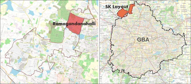
Maps: Integrated Design
Over the past few decades, the idea of ‘planned layouts’ has shaped the imagination of urban expansion (and development) across India’s cities, positioned as a necessary response to the pressures of urban growth. The implementation of this intent is far more complicated – frequently unfolding within speculative and contested landscapes shaped by prolonged land acquisition processes, legal disputes, political negotiations, administrative uncertainty, and rapidly transforming land markets.
Rather than resolving the pressures of urbanisation, these modes of urban expansion have (re)produced new forms of spatial inequality, ecological stress, infrastructural fragmentation, and socio-economic uncertainty. As the city expands outward, many of the externalities of speculative urbanisation[2] are transferred onto peri-urban agrarian communities whose lands, livelihoods, and social worlds are gradually absorbed by the expanding metropolis. What appears within urban planning discourse as land available for urbanisation is, in effect, a lived landscape shaped through generations of cultivation, memory, ecological relationships, and collective life.
The intention of The layout was first expressed by the Government of Karnataka through a land acquisition notification in 2008. It has since been marked by resistance. In 2015, it was halted by the High Court only to be reinstated by the Supreme Court in 2018. These reversals were interspersed with denotifications of 600 acres without a clear justification – a significant process violation. Nearly two decades later, conflict, litigation, uncertainty, and an alien transformation continue to be the norm.
This essay examines The Layout through the memories and experiences of farmers living within the notified area. While these experiences are perhaps not universal, they remain critical to understanding what urban expansion means beyond mere changes in land use. It signifies the sudden disappearance of socio-ecological worlds evolved through generations of stewarding and nurturing – cultivation methods, water systems, community commons, and associated social and cultural practices linked to individual identities and collective belonging. Thus, while not overstating the representativeness, the essay remains faithful to those with experiences, emotions, and interpretations beyond data that informs planned development such as The Layout.
The last fields
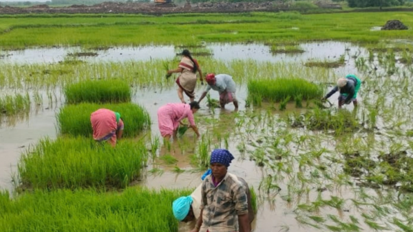
Kumar, a fourth-generation farmer and a resident of Ramagondanahalli, continues to farm parcels of land yet to be gridded. The land here is not merely a productive asset but an inheritance of memory, labour, and identity. “Even in my great-grandfather’s grandfather’s time…I cannot put into words how rich our village once was. There was no shortage of anything except money, which we never really needed.” His articulation of richness resists conventional economic definitions; it is rooted instead in ecological sufficiency, abundance, and social cohesion.
In walking around Ramagondanahalli, Kumar showed photographs of his agricultural land with pumpkin creepers and jackfruit and coconut trees, describing the landscape with a sense of pride and grief. In his memory, the village is yet not abstract nostalgia. It continues to exist as specific places, routines, and shared spaces that once structured everyday life.
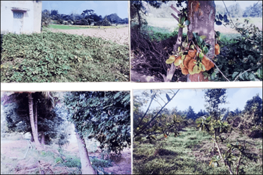
Photos: Kumar
The hydrological network of keres (tanks), kuntes (ponds), and kaluves (streams) was not accidental; these were design responses evolved over generations. Slow, labour-intensive, yet deeply sustainable. Their disappearance signals not just loss of heritage, but loss of climate resilience. “The keres were always full, the kanne (low lying areas) were covered with fields, and we were truly blessed with this fortune,” he says.
The Aswath Katte – a raised platform built around a tree (usually the peepal or the banyan)– sometimes a century old – served as places of worship, rest, social gatherings and resolution of village conflicts. “At that time, the platform was too tall for me to climb. The trees were huge. Three or four people together could not fully hug them.” Today, a compound wall encloses a remnant shrine holding a Nagarakallu (the serpent deity). Institutions such as the Katarayanagudi (temple of the village deity), and rituals associated with the Ondevaru (the only God) were not peripheral traditions but integral to how communities related to land, water, and each other. The Gomala (grazing commons), extending over 95 acres, provisioned cattle that provided milk, butter, curd, and ghee for household consumption and sale (when needed), in the adjoining areas. Today, it is a part of defence lands and institutional campuses.
Lived landscapes of water and trees
Water emerged as a central axis of this lived environment, both as an emotion and a taste. Referencing nearly eight (disappeared) ponds that “taught me swimming”, Kumar pointed to the surviving lakes now transformed into fenced and regulated urban water bodies with walking tracks and restricted access timings. Open wells that dotted the landscape had a distinct taste. The recollection of Halina Kunte (Hallu is milk in Kannada) with its “milky hue and sweet like sugar water” taste gestures an intimacy with water beyond utility. It is an embodied knowledge of colour, taste and seasonality that cannot be reproduced through engineered systems.
The shift from wells to borewells further signals a transformation in how water is accessed and understood. “Fifty to a hundred years ago, nobody dug borewells here, open wells were dug based on jaladakannu (water diviners).” This practice of identifying water through ecological cues represents a localised epistemology, one that is gradually displaced by technological extraction.
Marking the landscape were the remnants of the Gunduthopu – tree groves with jamun, banyan, tamarind, and peepal trees. Summer for him meant gathering different types of Jenu (honey) – Kaddi, Thore, Utudu, and Bettada jenu – with friends and eating it alongside jackfruit. These are “not things you can buy back with money”. Lived landscapes like Ramagondanahalli speak of relationships between water and soil, cattle and commons, seasons, livelihoods and people. The memories are not mere repositories of loss; rather these signify the sudden disappearance of an entire socio-ecological lived world.
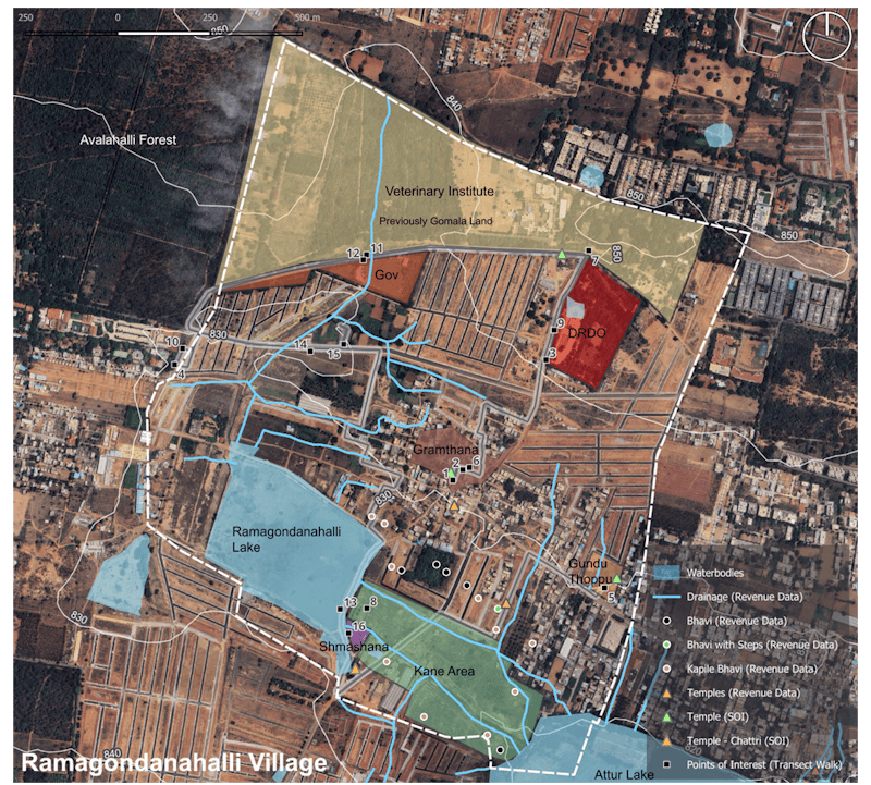
Map: Integrated Design, Bengaluru
The ground remembers what the plan forgets. Soil that held moisture, now reflects heat; cooler under-tree afternoons replaced by radiating tar roads; the sound of cattle bells replaced by construction machinery; and the smell of wet earth replaced by dust and cement. There is also a subtle but profound shift in time. Agrarian life follows cycles that are seasonal, ecological, regenerative. Urban layouts follow linear time: construction, allocation, occupation. In between lies waiting with years of uncertainty, halted work, suspended life. “Back then, everything was clearly defined, the gomala land, the graveyard, the gramthana… Nothing was confusing; every space had its place.” The clarity of these spatial and social arrangements stands in contrast to the ambiguity introduced by acquisition processes, where boundaries are redrawn through surveys, notifications, and legal disputes.
Kumar’s narrative is neither singular nor homogenous. For many, The Layout unleashed aspirations of connectivity, commerce and integration into the city. A farmer near Doddabettahalli frames development as necessary and desirable; the integration into the urban fabric offers economic opportunity and social mobility. Another shopkeeper is happy with the development because “business is going well”. These voices highlight the heterogeneity of aspirations, the differentiated impacts of urban expansion. Yet, even among those who welcome development, uncertainty and disruption remain and delays in project execution, incomplete compensation, and prolonged transitions create precarious conditions.
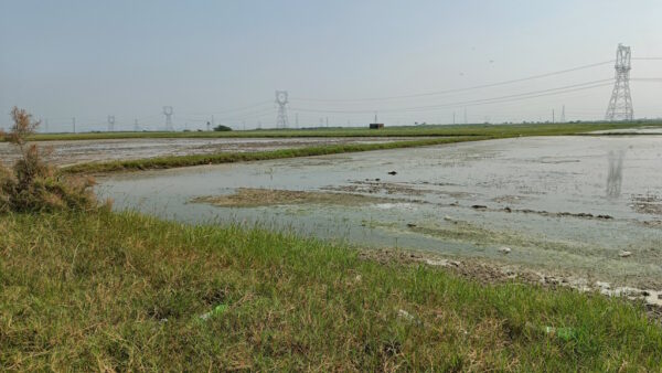
The same infrastructure that enables mobility also fragments land, disrupts natural water cycles, and alters social relations. A kaluve constructed in The Layout was once “nearly 30 feet wide and 12-13 feet deep…stands severed with the acquisition… when the water stopped flowing, the acquisition happened, and the kaluve lost its identity.” Here, infrastructure does not merely overlay the landscape; it actively reorganises hydrology, often with irreversible consequences.
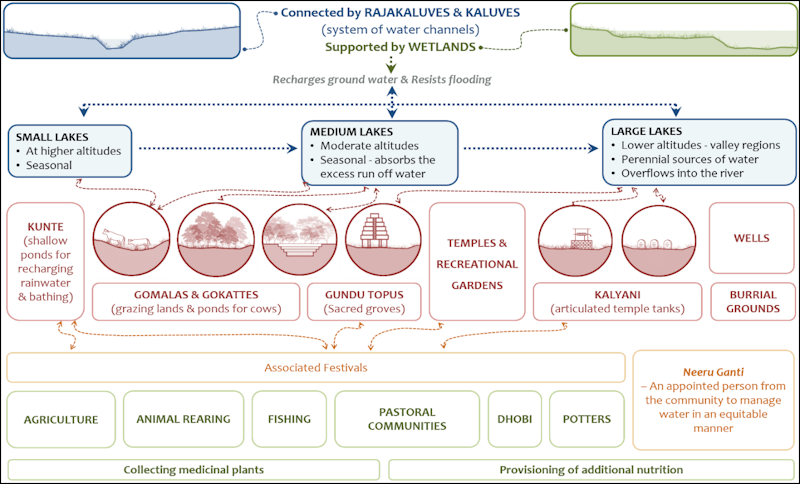
Illustration: Integrated Design
The questions that remain
One of the deepest sources of frustration is the prolonged uncertainty through which the process unfolded. The land acquisition conflicts and ensuing resistance normalised as part of the expansion process marks emotional exhaustion, suspended livelihoods, and an inability to make long-term decisions about life itself. “Development has been delayed… whether the farmers will get the allotment, we cannot see,” says Kavitha, a small shop owner in Ramagondanahalli. “For the last three years, we have been told to vacate…we cannot replenish goods in the shop.” Extended periods of instability before any promised benefits materialise.
The Supreme Court ruling to reinstate the layout halted all denotification calling out the undesirable speculation associated with de-notifying land. A ground level verification by a SC-appointed committee documented (digitally) nearly 7,000 buildings in the layout area, many of these showing diverse forms of illegality. Following this, compensation certificates and regularisation documents were issued. Several measures were introduced to ensure transparency in the compensation and regularisation, “maintain procedural integrity, ensure that compensation records remained secure and traceable…. [after which many amongst the affected communities appeared to] gradually regain confidence that at least the compensation process would proceed more fairly and systematically under the court-monitored framework” (interview, Member of the SC-appointed committee).
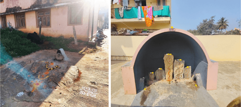
Photos: Justin Andrews Jeganathan
These corrective mechanisms came a decade too late. Even as uncertainty, speculation, litigation, and administrative inconsistency persisted, substantial private gains were extracted through informal transactions, political influence, legal ambiguity, and administrative loopholes.
The shift “from green to grey” is not simply aesthetic but existential. Development, as currently practiced, prioritises spatial and economic metrics over experiential and ecological ones. As one farmer asks: “What is important for development, what is the paramount? Our life, our health or such development?” This question challenges dominant paradigms, necessitating a rethink of what constitutes value in urban transformation. If the aim of urbanisation is to enhance quality of life, then the experiences from Ramagondanahalli suggest a need for recalibration. The landscape that was once walkable and a rich tapestry of localised economies stands fragmented in the name of ‘development.’ What remains, ultimately, are fragments of land, of memory, of identity.
Ramagondanahalli’s story raises critical questions: In what ways can urban planning acknowledge rural landscapes as not subordinate to the urban? How can these repositories of cultural richness, historical continuity, ecological intelligence, and deeply rooted emotional worlds be meaningfully engaged with beyond monetary compensation? And, how might built environments be designed to sustain, rather than sever relationships between people, land, and water? Development may redraw maps and reconfigure landscapes, but it cannot fully erase the lived histories embedded within them. The challenge, then, is not only to build or expand cities, but to do so in ways that acknowledge, respect, and learn from the worlds they replace.
Even as we write this, the government has announced the second phase[3] of The Layout seeking to acquire roughly 2,000 square kilometres. While it is not clear if institutions have learned from nearly two decades of conflict, litigation, uncertainty, and distress, there appears to be limited evidence of deeper structural efforts to holistically address the long-term social, emotional, and livelihood-related concerns that continue to linger within affected communities for decades. If this next phase reproduces the patterns of speculation, procedural confusion, prolonged uncertainty, and the gradual indignification of farming communities in the peri-urban landscapes, what would have been achieved?
Anjali Karol Mohan, PhD is an urban and regional planner-researcher, and a partner at Integrated Design, leading action research on decentralised, climate-responsive planning in Indian cities.
Neeth D’souza is a Social Impact practitioner, working at Integrated Design and is experienced in grassroots project management, community engagement, and stakeholder coordination across diverse communities.
Justin Andrews Jeganathan is an Environmental planner at Integrated Design exploring ecology, governance, and community resilience, with an interest in socio-ecological systems research.
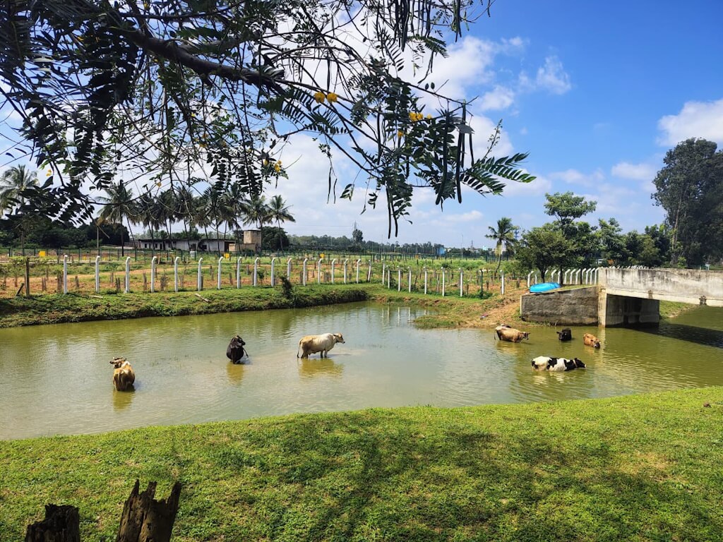
Cover photo: Ramagondanahalli Lake, now transformed into a fenced walking park, while still being used by cattle for drinking and bathing. Credit: Justin Andrews Jeganathan