Punchiri Mattam, in Malayalam, carries a profound meaning — an elevated abode of happiness. Located on the environmentally- sensitive slopes of the Camel Hump mountain ranges in Wayanad, in northern Kerala, Punchiri Mattam, with its enchanting beauty and rich flora and fauna, was a paradise for nature enthusiasts. Once, the meaning was a fitting description of natural beauty in the picturesque plantation town, the name starkly contrasts with the annihilated place that it faces in the aftermath of the massive landslides on July 30.
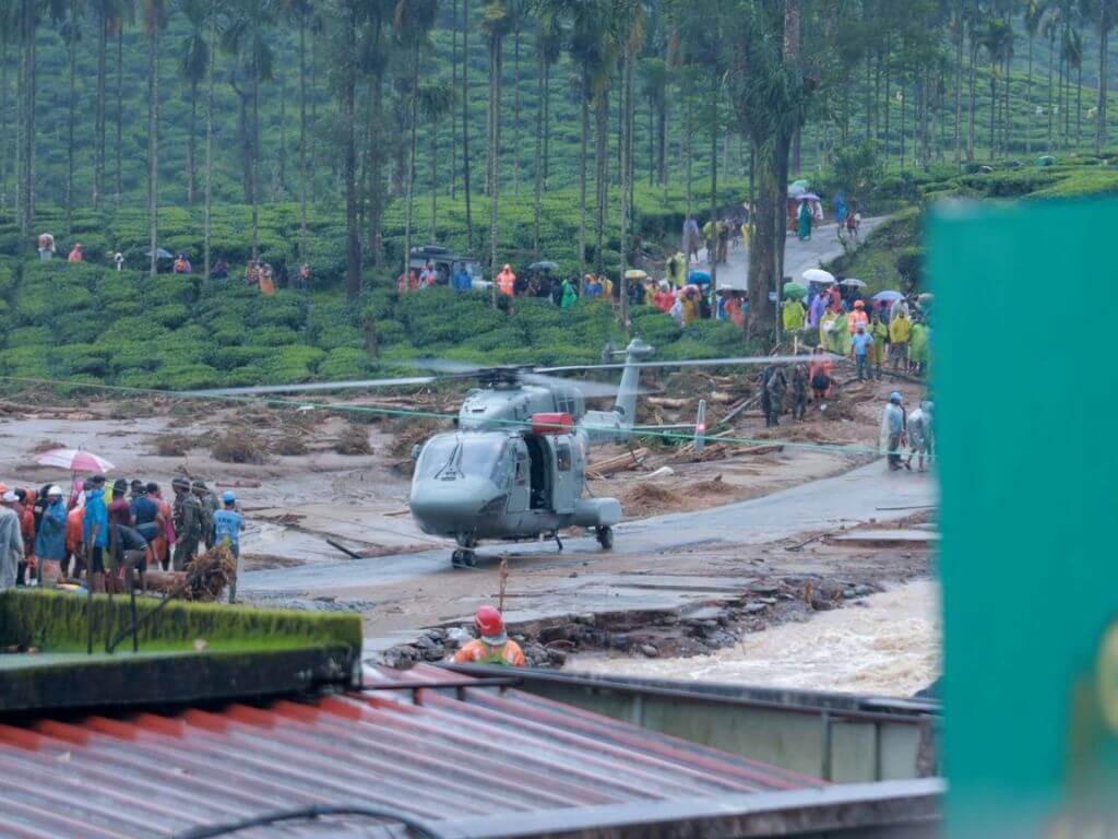
Its adjoining villages of Mundakkai and Chooralmala have also become symbols of deep and lasting sorrow for Kerala. The deadliest landslides in Wayanad’s history have erased these villages from the map and transformed the whole area into a ghost place, underscoring the need for extensive support after the relief efforts. The death toll crossed 402 in a week and 154 people are still missing. More than 7,000 people who lost their lands, houses, and livelihoods are currently living in makeshift rehabilitation camps set up downhill.
There is little hope in what’s possibly the largest climate crisis-induced tragedy that Kerala has seen since the massive floods of 2018. Seventy-year-old Annayyan, a plantation worker from Punchiri Mattam, and his family miraculously escaped the disaster. However, he lost his house and two acres of agricultural land. Living in a relief camp, his only request is for permanent rehabilitation within the town. Wayanad, famous for its vast expanses of coffee and tea plantations, is vulnerable but it is home to him. “I don’t want to leave the district, as I can only work as a plantation labourer. Outside Wayanad, my life and livelihood would be at stake,” he says.
As the rescue work ebbs, the state government has begun discussions on developing townships to rehabilitate all the survivors.[1] These townships, according to plans, will be equipped with all the civic facilities such as access to better education, employment, and healthcare. However, the biggest challenge is finding land outside the district’s environmentally-fragile areas to develop these sustainable rehabilitation projects.
Vulnerable Wayanad
An integral part of the Western Ghats, known for its tourism and large-scale cash crop production, Wayanad is now among the places in south India where the impact of climate change and global warming are acutely felt. A recent study by the popular science movement, Kerala Sasthra Sahitya Parishad, and Hume Centre for Ecology and Wildlife Biology based in Wayanad, found that only 30 percent of the district’s 2,132 square kilometres can be useful for safe dwellings and agricultural activities. Wayanad district has a population of nearly eight lakh. Finding safe alternative land for rehabilitation of the survivors within the district is quite challenging.
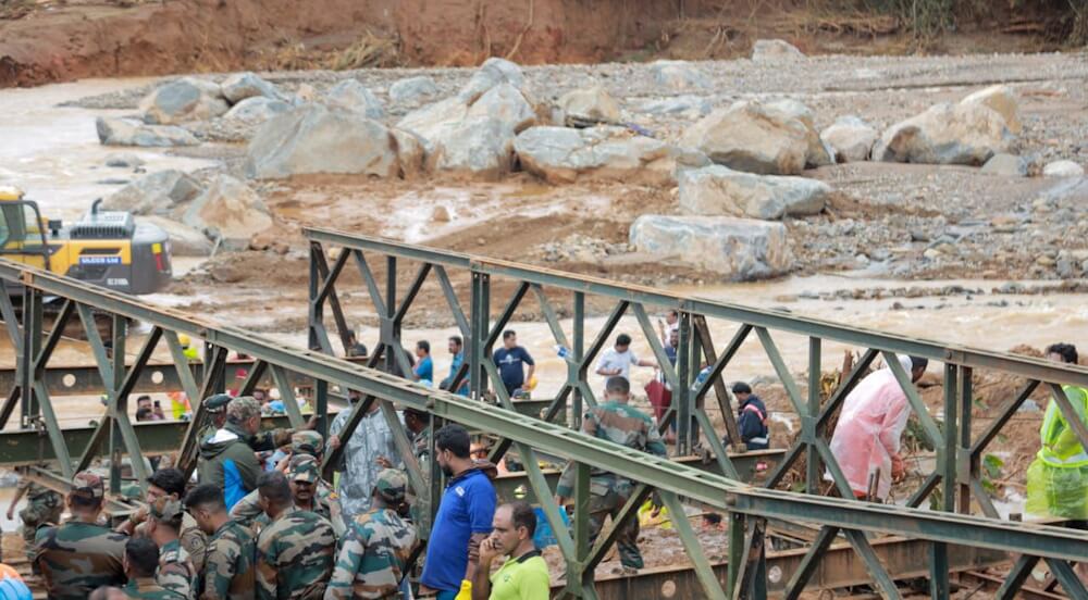
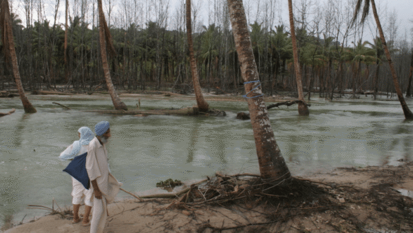
Photo: Akhin Sreedhar
Wayanad is situated in the highly-sensitive Nilgiri Biosphere Reserve. It is closely connected to tiger reserves and wildlife sanctuaries in neighbouring states such as Bandipur, Nagarholai, Mudumalai, BR Hills, Silent Valley and Sathyamangalam.
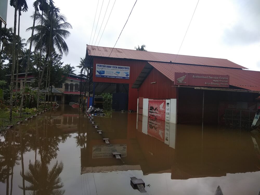
Since 2018, Wayanad has been experiencing extreme annual weather events[2] and is facing various environmental challenges, including deforestation, irresponsible tourism, encroachment on tribal land, conflicts between humans and animals, and the urgent need for sustainable and scientific development projects. Across the district, soil erosion is very high and becomes acute during the two monsoons every year.
The latest study report by the state’s soil conservation department[3] confirms that 70 percent of the district’s natural streams have disappeared[4] because of climate change and human factors that have aggravated the crisis. Only 26 percent of the feeders of the district’s mighty river Kabani, which merges with the Kaveri, are functional because of the adverse changes in land use patterns, says P U Das, former Wayanad district soil conservation officer when contacted.
The people who are most vulnerable to climate-induced disasters are the poorest in the district – landless plantation workers and tribals. Even in the latest tragedy, those who became victims of the landslide were mostly plantation workers and nominal farmers. “Adivasis constitute 18.53 percent of Wayanad’s population. Plantation workers, who do not own land, make up around six percent of the population. These people become the most vulnerable segment during extreme weather events,” says N Badusha, president of local environmental organisation Wayanad Prakrithi Samrakshana Samithy.
It is worth recalling that during the 2018 floods too, Wayanad had witnessed a staggering 1,132 small and medium landslides. There were two massive landslides the following year. In these, 86 percent of the victims were tribals and plantation workers. The forest cover and the paddy lands, icons of Wayanad, are now quickly shrinking,[5] raising large-scale concerns about what lies ahead. Among the 25 gram panchayats of the district, 17 are environmentally fragile, and two among the three municipalities are also unsafe.
Ignoring warnings
Despite the fragility, Kerala Tourism Department continues to promote Wayanad as one of the top 50 must-see destinations in the world and it has been featured in international lists for tourists.[6] The settled wisdom is that unregulated tourism has significantly contributed to the district’s present state.[7]
A recent comprehensive study[8] by social anthropologists, Ursula Munster of Ludwig Maximilians and Daniel Munster of Martin Luther University, Germany, found that “nature tourism poses a serious challenge to the biodiversity, wildlife, and highly vulnerable tribal communities in the Wayanad region.” Their six-year-long research reveals the negative impacts of nature tourism including the exploitation of tribals and contribution to the prevailing climate crisis. Instead of solving the agricultural and ecological crisis in Wayanad, tourism has led to the ‘zooification’ and ‘exoticisation’ of tribal communities, the researchers state, describing this phenomenon as verging on racism.
In Wayanad, many are aware of the warning from well-known environmentalist Prof Madhav Gadgil, in 2023, about potential landslides that might affect Meppadi, which includes Chooralmala, Mundakkai, and Punchiri Mattam. Following the 2019 landslide at Puthumala, just two kilometres from Mundakkai, Gadgil emphasised that the entire region was vulnerable to more landslides and that another could have devastating consequences. Gadgil’s warnings confirmed what the state authorities, in 2018, had identified – 22 high-hazard zones including the Mundakkai-Chooralmala region.
However, this expert opinion did not lead to concrete preventive steps and no action was taken to improve the daily and decentralised local-level weather forecasting or to relocate people from vulnerable areas. Despite extreme weather events occurring annually, there have been no efforts to initiate advance relocation.
“The recent catastrophic landslide in Wayanad prompts us to reflect on the need for improved forecasting of extreme weather events,” opines CK Vishnudas, director of Hume. “For instance, although Kerala typically receives an average rainfall of 2,018 millimetres during the four-month southwest monsoon, a closer analysis of rainfall data from certain stations managed by the India Meteorological Department (IMD) over the past century reveals that the hilly regions adjacent to the Western Ghats receive approximately double the average rainfall due to the influence of orographic features on the monsoon. This substantial variance in rainfall underscores the need for a separate, more specific, weather warning for the ghat regions in Kerala, especially considering the large population residing in landslide-prone areas compared to the core monsoon regions along the west coast,” he adds.
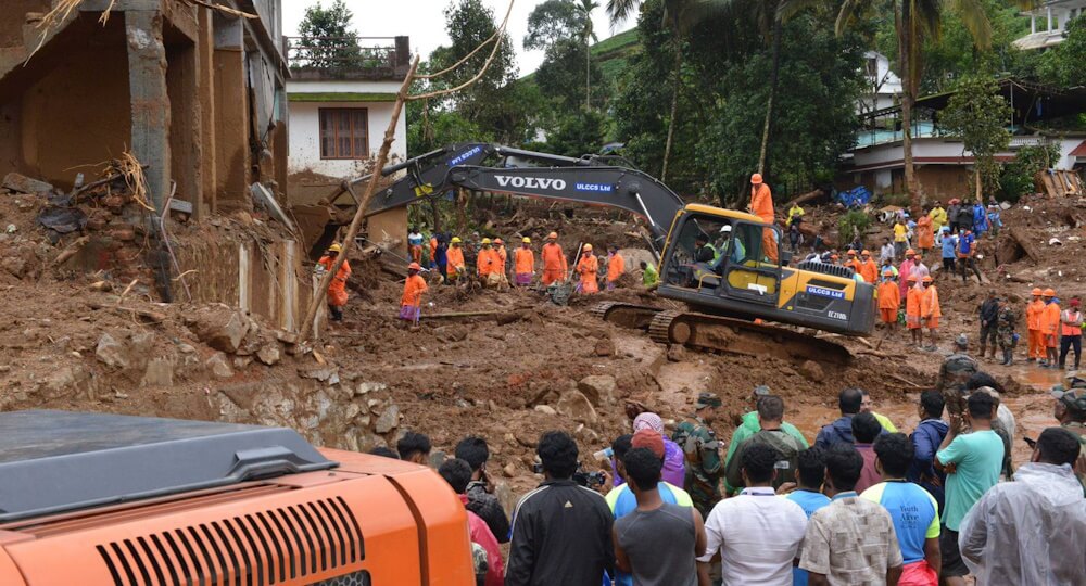
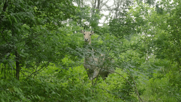
Photo: Akhin Sreedhar
Uncontrolled development
The heavy rainfall triggered the landslides but the uncontrolled development for tourism and quarrying has greatly disturbed Wayanad’s delicate landscape, said Wayanad-based social activist OK Johnny. “Prof Gadgil chaired the Western Ghats Ecology Expert Panel in 2011, which designated the affected area as ecologically sensitive (ESA 1). The committee recommended prohibiting construction, mining, and quarrying activities in large parts.” These activities were not regulated.
Wayanad district, mostly on hill slopes, has seen quarrying, hill levelling for construction, extensive road building, expansion in the hills, and mono-crop farming without a care for their ecological impact. These activities, combined with heavy rains intensified by climate change, have led to landslides. Four years ago, a landslide in Puthumala revealed the emergence of soil piping – a hydraulic process which creates large air-filled voids in the subsurface, often associated with landslides and subsidence.[9] Recent landslides in Mundakkai and Chooralmala suggest that soil piping may have been the cause.
TV Sajeev, principal scientist of the Kerala Forest Research Institute, stated that heavy rains lead to landslides.[10] However, quarrying, construction in the hills, extensive road building and expansion, and mono-crop cultivation all worsen the situation. Mono-crop tea estates are seen in Chooralmala and Mundakkai, and the area has a sizable tourism infrastructure due to its proximity to the Meenmutty Waterfalls. Despite regulations, several tourist resorts have been built in highly-fragile areas; why these were allowed is anybody’s guess.[11]
The office of the South Wayanad Divisional Forest Officer confirmed to me that at least 30 such resorts are functioning in the Thollayiram Kandi forest region, from where the aerial distance to the landslide hit Chooralmala-Mundakkai region is hardly one kilometre. The then DFO, Sajna Karim, had reportedly informed the Kerala government last year that at least 2,500 tourists engaged in off-road tours, provoking the possibility of landslides, and that the resorts also prevented the flow of Kalladi river which can minimise the impact of extreme rainfall.
According to the landslide hazard map of the Kerala Disaster Management Authority, over 40 percent of the Wayanad district is susceptible to landslides.[12] The Meppadi region is particularly prone. Kvalappara in Malappuram district, opposite Meppadi mountains, experienced a massive landslide four years ago. However, despite annual floods and landslides, little progress has been made on relocating people in the fragile zones.
Geoscientist CP Rajendran, faculty in Bengaluru-based Jawaharlal Nehru Centre for Advanced Scientific Research, emphasised the urgent need for Kerala to establish clear land management and water utilisation policies. Additionally, the state must develop long-term strategies to address annual floods and landslides, which disproportionately affect poor communities. Rajendran also stressed, “The importance of extreme care in land use patterns, cautioned about locating large-scale projects with significant environmental considerations, and recommended that the state establish zoning regulations for land use including preparing “landslide susceptibility data”.”
Unfortunately, current practices do not take these crucial precautions, which exacerbates the harm in case of landslides. Nearly half of Kerala is hills and mountainous regions with slopes exceeding 20 degrees, making these areas particularly prone to landslides during heavy rains. In Wayanad, rules prohibit any kind of land use on slopes exceeding 30 degrees and advise extreme care in areas with 22 to 30-degree slopes.
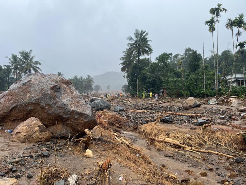
Photo: Akhin Sreedhar
The forests in Wayanad have been depleting at an alarming rate. A study conducted in 2022 revealed that 62 percent of the district’s green cover disappeared between 1950 and 2018, while plantation cover increased by approximately 1,800 percent.[13] According to research in the International Journal of Environmental Research and Public Health, before the 1950s, forests covered about 85 percent of Wayanad’s total land area.[14] However, the region now has extensive rubber plantations. The study also pointed out that the intensity of landslides has increased owing to rubber trees which are less effective in holding soil than the dense forest cover.
“The Wayanad catastrophe is a poignant reminder of the intricate equilibrium between the natural environment and human actions. This text emphasises the severe outcomes that result from ignoring ecological warnings and the urgent requirement to implement sustainable development methods to protect the environment and the livelihoods that rely on it,” observes climate expert Sreedhar Radhakrishnan.
In the light of the landslides, the Pinarayi Vijayan-led Left Democratic Front (LDF) government faces mounting pressure to halt the controversial Rs 858-crore project for India’s third-largest tunnel road which involves drilling into the same mountains that house the landslide-struck Chooralmala-Mundakai villages. The 6.8-kilometre tunnel, a favourite Vijayan project, is meant to ease traffic between Kozhikode in Kerala and Mysore-Bengaluru in Karnataka. Despite the disaster, the government has been silent about reviewing or reconsidering it. What will wake up the government?
KA Shaji is a South India-based developmental journalist specialising in environment and climate change. He regularly writes for The Guardian, Hindustan Times, Mongabay, and Down to Earth, covering topics such as politics, social inclusion, rural development, Dalits, tribals, art, and culture. A postgraduate in Journalism and Mass Communications, Shaji is the recipient of National Media Fellowship from the National Foundation for India for Excellence in Journalism and has also been honoured with Sanskriti National Journalism Award for a series of articles on the agrarian crisis in Wayanad.
Cover photo: Akhin Sreedhar