Nearly 20 years after the massive flood of July 26, 2005, there is talk about flood management and mitigation measures. But have they really been put in place? How does Mumbai’s planning framework impact its ecology and flooding? Question of Cities took these and other questions to three people in Mumbai well-versed with the city and its development.
Architect and urban researcher Shweta Wagh, an associate professor at the Kamla Raheja Vidyanidhi Institute for Architecture and Environmental Studies, stresses a holistic ecological planning approach. Lubaina Rangwala, Program Head, Urban Development and Resilience with Sustainable Cities and Transport team at World Resources India suggests breaking the Mithi’s retaining walls and creating green buffer zones and open forests. Stalin D, a conservationist and director of NGO Vanashakti, says that the city’s rivers are urban commons and people need to reassociate with them and claim them back.
SHWETA WAGH: ‘Quick fixes cannot stop flooding; planning must take ecology into account’
 Has Mumbai done enough to prevent flooding and allow the rainwater to drain?
To prevent flooding, we must understand the relationship between land and water. Rainwater can either be absorbed and contained by land or allowed to drain into natural water bodies. However, the focus of the government on flood-mitigation has predominantly been on hard engineering solutions, such as concrete embankments along rivers and nullahs, storm water drains, and pumping stations designed to divert and flush out storm water. Many of these disrupt the existing ecosystems and drainage patterns, and shift flooding elsewhere. For instance, the natural streams and rivulets in Aarey were channelised with concrete embankments, destroying their riparian areas, causing flooding in surrounding areas. On the other hand, as I mentioned in this essay, https://questionofcities.org/techno-fixes-for-flood-risk-mitigation-in-mumbai-an-ecological-critique/ the recent focus on soft infrastructure, also termed ‘nature-based solutions,’ take the form of localised mitigation measures, and do little to address the root causes of flooding.
The city needs a holistic ecological planning approach – which involves an understanding of topography, geomorphology, hydrology and ecosystem services. We need to prevent the opening up of relatively undeveloped catchment areas of rivers such as in Aarey and treat them as infrastructure for flood mitigation. We need careful documentation and re-zoning of natural ecosystems – and integrate them as flood prevention infrastructure. We need to allow ecosystems that have degraded over time to regenerate. We also need development controls and retrofitting of the existing formal builtscape to enable permeation. And all of this needs to happen as an integrated planning approach, rather than as piece-meal projects.
Is Mumbai better or worse placed to handle a situation like July 26, 2005?
The current Development Plan of Mumbai as well as the regional plan for Mumbai Metropolitan Region propose to open up more land for construction. The regional plan proposes to increase the urbanisable land from the existing 800 to 1,336 square kilometres. The Mumbai DP incentivises redevelopment by increasing Floor Space Index or buildable area. Meanwhile, the Coastal Regulation Zone has been amended to allow high-intensity construction and land reclamation for infrastructure projects, and environmental regulations have been watered down. Development Control Rules are periodically relaxed to increase building footprints and reduce non-concretised areas such as marginal open spaces around buildings.
Planning is exclusively focused on land use and development control rules. There is little or no thinking about the preservation and conservation of natural areas (other than legally designated natural areas), flood prevention and control, water supply, drainage and sewerage, etc – all of which are mandated by the Maharashtra Regional Town Planning Act. In the plans, there is little evidence of comprehensive assessment of ecological systems, land cover change, and environmental risks. Even the Mumbai Climate Action Plan, only considered legally notified areas like reserve forests and mangroves as areas worthy of protection.
What is generally done for flood mitigation is either seasonal clean-ups of rivers and drains before monsoons or ‘urban greening’. However, unless planning frameworks begin to incorporate an ecological perspective, the city is going to be more vulnerable to urban floods and other environmental hazards.
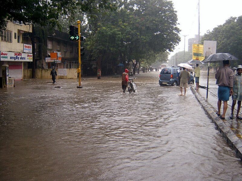
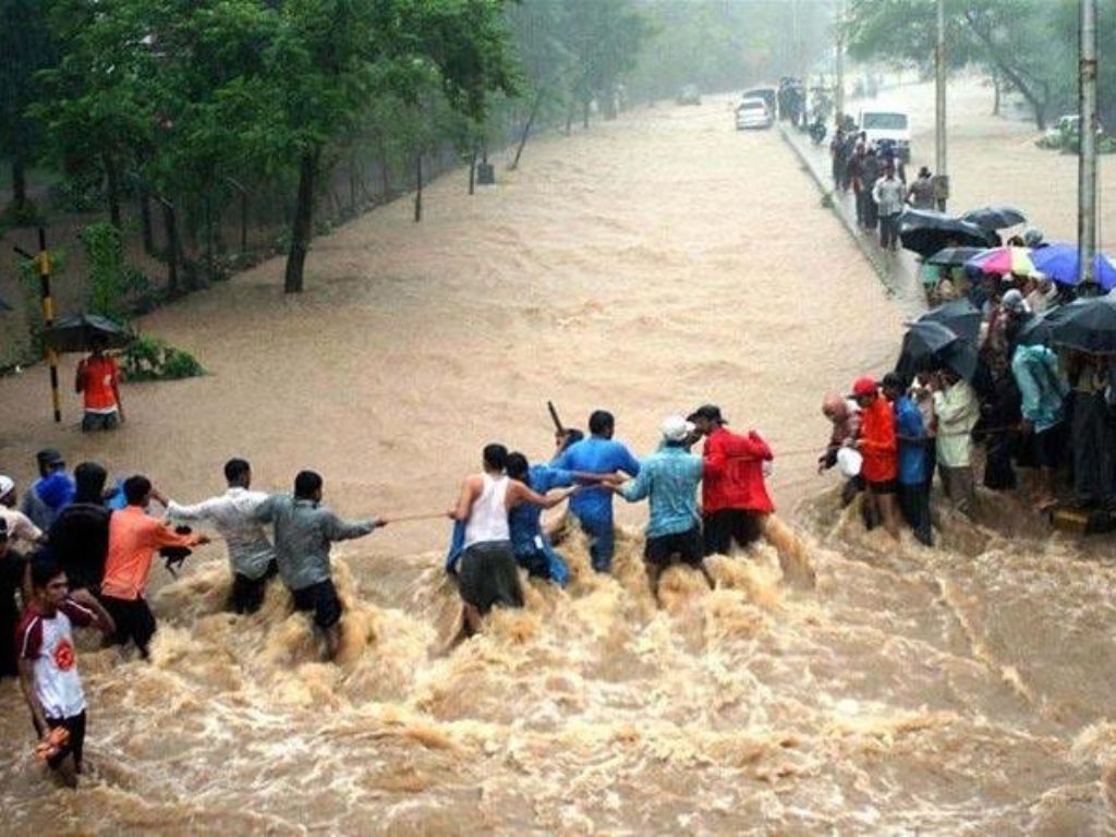
Photo: Inexplicable/Flickr
Why has this not happened?
It is obvious to everyone that the real-estate industry sets the priorities of development in Mumbai. As opposed to regulating the sector, development authorities have become promoters and beneficiaries of real-estate speculation. Ecosystems are seen as a hindrance to potential ‘development.’ As the public sector has stepped back from its functions of regulating growth and provision of public goods and services, what is called ‘planning’ has come to mean mitigation measures, “green infrastructure” fixes, beautification projects. These are now proffered as substitutes for degraded and depleted ecosystems.
If we are to be serious about environmental risks, we would need to undertake a systematic and comprehensive review of the existing plans and projects. A city that is reclaiming the sea and creeks to build coastal freeways, that incentivises indiscriminate redevelopment, that conceives of land as an object of real-estate speculation is not a city that is preparing for the worst-case scenarios of climate change.
LUBAINA RANGWALA: ‘Imagine a landscape, a hundred micro projects, to hold rainwater’
 Has Mumbai done enough to prevent flooding and allow the rain to drain?
Flooding has historically been a challenge for Mumbai. Infrastructure upgrades have happened in the last five years, like modernised pumping stations. In the areas where chronic water logging is an issue, pushing the water out is a challenge. Over the years, percolation is zero. With the concretisation of roads and increased urbanisation, there’s no natural ground left. Mandatory open spaces in buildings are at the podium level. Rain falling on them is pushed out through drains instead of reaching the ground.
We need to collectively think about how to increase natural buffers that hold water in traditional ways. We have mechanised solutions. Retaining walls have been raised high where the Mithi is now functioning as a drain instead of a river. There are also interceptors along the Mithi to make sure it flows but the challenge is when the backflow happens during high tide. Outside my home, there is a chronic flooding hotspot which needs only an hour of rain to become flooded. Every monsoon, there are reports of water logging and some are determined as hot spots. The solution has been to install a pipeline or a pump. We need to make watershed models to understand how to manage localised flooding.
The topography has to work as one system where open spaces become holding water ponds, which was traditionally the case. Playgrounds collect water when it rains and are used as a ground when dry; these have disappeared or have astroturf. The current narrative is that if we get 200 millimetres of rain, we cannot do much about it. We have to think about how much concrete has been poured into the city. For the storm water department, the mandate is to build infrastructure to drain the water out but not slow it down and detain it. A new landscape approach can be adopted and institutionalised where green and blue buffers can be used to augment existing infrastructure. Private plot owners can equip their homes to save rainwater. But instead of this approach of resolving hot spots we need to take up a catchment management approach, with a combination of hybrid solutions when modelled at the catchment level will help manage localised flooding.
Is Mumbai better or worse equipped to deal with a flood like July 2005?
No city in the world could have managed the amount of water Mumbai had in 2005. Mumbai is better equipped than it was then but it is not only about that deluge. Flood management is not only drainage. Devastation happens in the poorest of neighbourhoods even now. The formal parts of the city are fairly developed but the effort is not into “informal” places. The question is: can we accept this devastation while living in a fairly aggressive climate? Climate has changed. Thankfully, the city has not received over 900 millimetres of rain since but loss has happened in the city in other ways – people falling into manholes, airport roofs falling, billboards falling.
A different approach to infrastructure is needed. For example, Singapore has ABC guidelines where they recognise their natural drainage lines like rivers as important infrastructure. Mumbai has eroded its natural systems. They are either polluted or filled with solid waste. Instead of open spaces, our streets are becoming spaces that hold the water. One of the important drivers is the development plan. This cannot only be the burden of the corporation, everyone has to do it together.
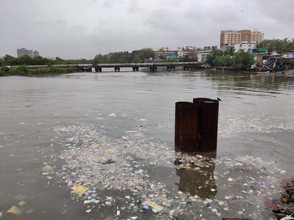
Photo: Jashvitha Dhagey
What does the future of the Mithi look like?
In 2005, the idea that the river failed the city was operationalised. Then, infrastructure was planned for it. Nothing could have been done differently for the Mithi to have performed more functionally than it did; the amount of water was overwhelming. Mithi is functioning as a drain now but, before the walls were built, its floodplains could soak water. During high tide, there’s no stopping the water from flowing back. The question is whether it is actually a river because naturally it is like an outfall surrounded by natural landscape. When the walls were built, its landscape was completely eroded. Now, it is most definitely a drain.
It’s hard to dream of a future where we can begin to rebuild. There are possibly catchment areas across the city. The long-term vision should be that each catchment area can work efficiently in retaining water locally. It’s not necessarily only about Mithi itself, but also its surrounding areas and open spaces whose terrain can be visualised differently. Small scale solutions can operationalise a larger landscape approach.
Another problem with the Mithi is the complexity of solid waste management. It’s not about building plazas or having a romantic connection with the river. Let us stop polluting it so that it can function as an outfall in the first place. Wherever possible, break the retaining walls and create green buffer zones and open forests. The imagination of a flood-able landscape also includes vegetation where trees that can survive being in deep water are planted. Replace concrete walls with gabion walls. Percolation is important. From retaining walls to the river bed, there is no possibility for water to actually enter the earth now.
There has to be a more holistic approach. We need to create breathable pockets. For example, the urban forest in Marol serves as a detention place for water. If we do 100 micro projects, then these will work together. Right now, small punctures are happening locally.
For Mumbai, we arrived at the MCAP from a climate hazard and vulnerability lens. More than 50 percent of the people live in informal settlements, their carbon footprints are not very high and their needs are not really going to be met by decarbonisation. The process of climate action planning is a journey. The MCAP is very much a living document. Through the process of MCAP, we categorically depended on formal data as the first baseline; the plan has broad targets and actions.
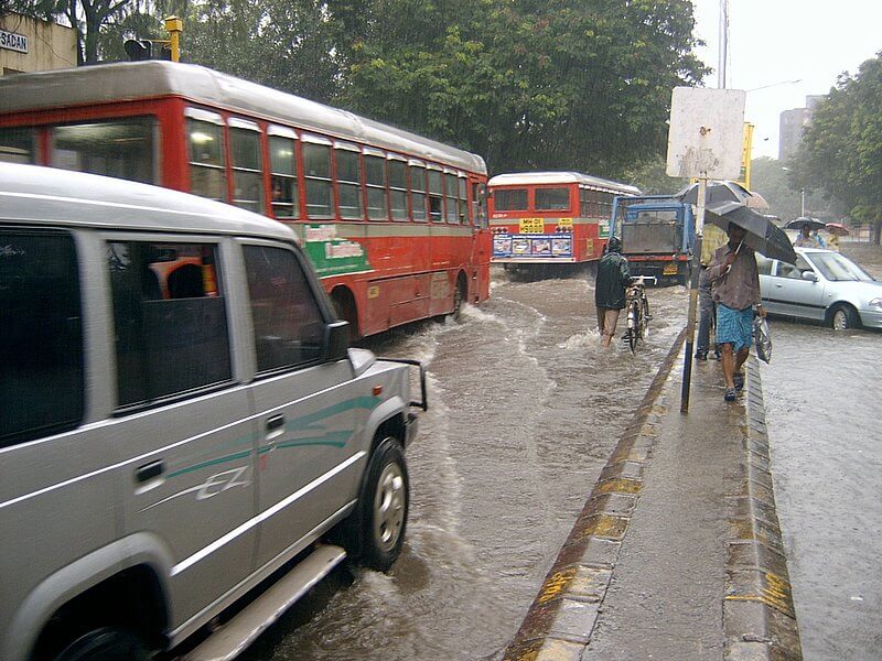
Photo: Inexplicable/Flickr
STALIN: ‘BMC functions like a real estate agency, flood control measures are absurd and unscientific’

Have we done enough as a city to stall flooding and allow the rain to drain?
We have done nothing but work on the Mithi river to increase its carrying capacity. The Brihanmumbai Municipal Corporation and Mumbai Metropolitan Region Development Authority decided to use the July 2005 crisis to create land for redevelopment. Most areas, especially around BKC or near Powai where the floodplains are supposed to be, have been constructed. Even the origin of the river at Powai and Aarey is walled – the only river in the world which has walls at its origin. This shows the intent of the government.
The result is that land is available for construction. Now, under the guise of desilting, funds are sanctioned. I am stating on record here that the official figure of 300 millimetres rain last week is wrong. It was much less. The authorities are inflating figures to fool people. If Mumbai receives 300 millimetres or more, it will go under. All of Mumbai’s rivers are walled – Dahisar is, Poisar has 15-feet walls around it but the water still overflows onto the road. In Poisar, there is also a car park on the river which shows how serious Mumbai authorities are about handling floods or allowing the river to swell.
The second issue of water not percolating into the soil is because every available open ground space has been concretised. So, the runoff has increased. This is stressing out the vegetation, increasing the temperatures of the city, and also increasing the flooding potential. Even areas like Aarey Colony which are actually forest interacting with the river are seeing floods now because of the retaining walls. The BMC and MMRDA have used the July 2005 crisis to profit from real estate and so-called flood control measures which are absurd and unscientific. There’s a lot of scope for commerce in a crisis.
Is Mumbai better or worse equipped to handle a flood like 26/7?
The city has gone from the frying into the fire; there’s now the Coastal Road too. Rainfall above 300 millimetres will create havoc. Pumps have been installed. This is a tactic to fool people that water is being pumped out into the sea while the sea is gushing in through manholes and other openings during high tide. The pumps are a failure. The authorities must be rubbing their hands in glee because their next agenda would be to dig up all the roads of Mumbai (again) to install new water channels under them to keep the city flood free. In calculated ways, they are taking us back into a cycle from which we cannot escape.
How would you interpret the disconnect of the city with its water bodies?
Every river is supposed to have a flood line mark but BMC refuses to allow the water resources department to take control or direct how Mumbai’s rivers should be protected. All the rivers are owned, controlled, and tampered by the BMC without any scientific advice and the civic body functions like a real estate agency. Whatever real estate developers want will be done. I can show you saltpans where people do not live but walls have been constructed in ways that create land parcels. And construction has already begun on some. So, this is only a land creation exercise. Even in the courts, it takes decades for any meaningful order against the BMC. So, it has a free run with enormous clout.
People need to reassociate with the city’s rivers and claim them back. It is the urban commons. I took the issue to the Supreme Court which appointed a committee which submitted a report on the Mithi. But the judicial system has failed me. The BMC has played mischief by delaying the entire process and nothing has come of it. The expert committee report should have been implemented but the authorities have the audacity and privilege to ask for what they want, in the court. Also, citizens are least concerned; show me ten people who talk about all this.
How have PILs helped?
Through PILs, we have managed to protect the wetlands of the Mumbai Metropolitan Region from reclamation and construction. The ‘water spread’ areas are still there. When high tide comes in, it still spreads itself in the mangroves. We got coastal areas protected. We also saved Powai Lake whose drainage would have been affected if the BMC’s idea of a cycling track was made inside the lake boundaries; the track could have been elevated but they wanted it inside. We stopped it.
Similarly, for all the lakes in Mumbai, we are trying to see that boundaries are not concretised and the natural interaction between the water and the land remains untouched. That is also the basic principle to be followed for flood management. Even Thane’s lakes started flowing with only half the rainy season having gone by. That explains how bad the situation is. If you take away the forest upstream and build walls along the course, the river gets silted. Then, money is spent on removing the silt. Nature has no space and natural solutions are never explored, sadly.
Cover photo: Sukhdev Mourya/Flickr