“It is observed that whether the development is planned or unplanned, authorised or unauthorised, it is driven only by forces of property development and not by civic amenities or infrastructural services or environmental factors. Property development has severely affected the natural ability of the city to manage rainwater in an environment-friendly way.”
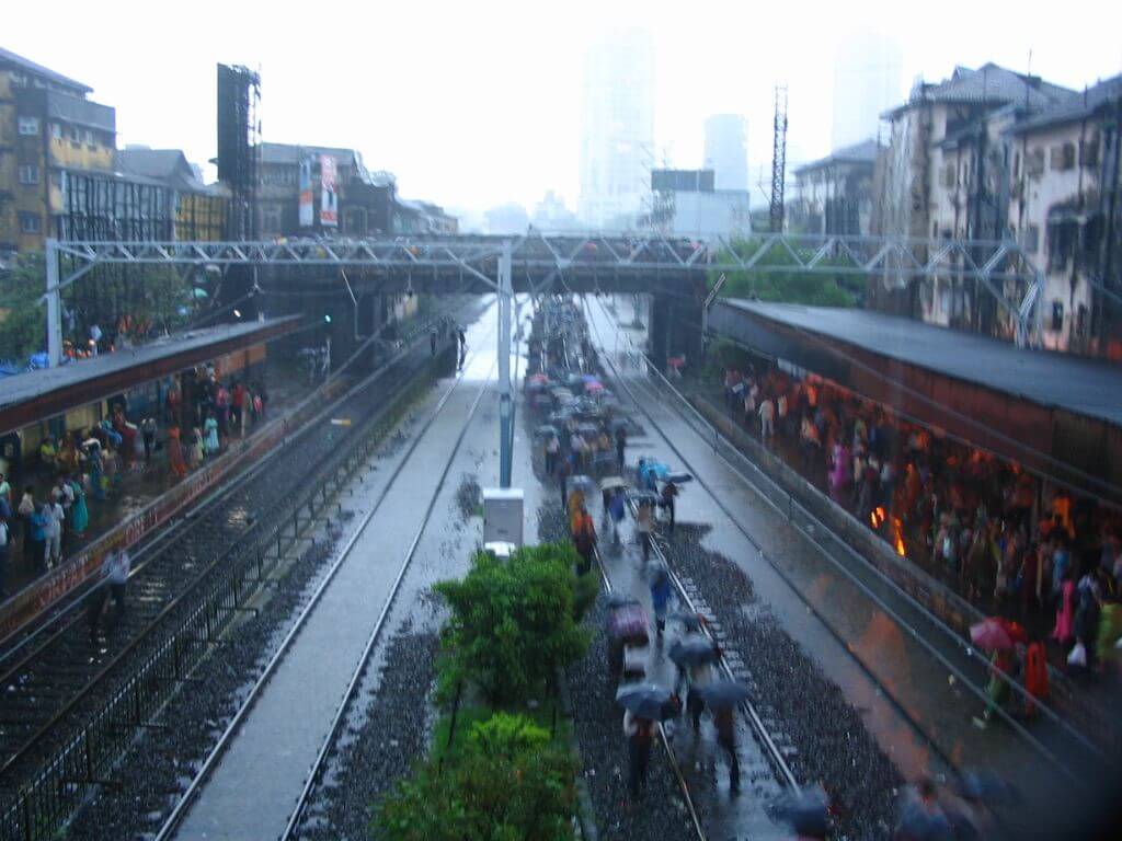
This paragraph, numbered 9.15, appears in the fact-finding committee report into the July 26, 2005, flood in Mumbai. It pulls together key issues that contributed to the massive flooding that fateful day. The paragraph could have been written in any week of heavy rain in 2024 and every word would still be true. This shows that, as the 20th year of the flood begins, other than pumping out rainwater and constructing walls along rivers, the situation has likely worsened in the planning and governance of Mumbai during rainfall even as climate change intensifies rainfall.
The fact-finding committee, chaired by Dr Madhav Chitale, hydrologist and former secretary of the union Ministry of Water Resources, submitted its report in March 2006. Since then, it has become a lodestar for the authorities in charge of keeping Mumbai flood-free. The detailed report, technical in parts and encompassing a range of subjects from hydrology and riverine systems to transport, health and communication, is a document that officials still use as a benchmark to score their flood-prevention work. The report has also been used by activists and groups to show up the shortcomings of the administration on this front.
Yet, nearly 18 and half years later, with climate change impacting the monsoon in Mumbai, including where and how and how much it floods, and the unbridled growth and redevelopment across the city changing its topography, it is time to look beyond the Chitale Committee’s recommendations. This is not to suggest that they are not relevant any more – the ones on command and control in disasters, transport systems, unification of multiple agencies, and Mumbai’s river ecosystems are valid – but they are limited and outdated.
The report predates the climate crisis in Mumbai. Climate science had warned of dramatic changes in weather and extreme events back then too but the impacts were not felt as sharply as in recent years. The report contains a chapter (number 7) on the environmental aspects but the focus is on flood prevention; not on ecological restoration of Mumbai’s natural areas which, in turn, could greatly help flood control. Importantly, it undermines ecology when it recommends more landfilling or reclamation for the city, relaxation of Coastal Regulation Zone law, and opening up of salt pan land.
Of the 58 tasks listed, the Brihanmumbai Municipal Corporation claimed last year to finished many.[1] However, instead of focusing narrowly on whether Chitale Committee’s recommendations have been honoured, the BMC and MMRDA must review them in the light of empirical evidence of climate impacts – and update the agenda to be carried out. Merely fulfilling the recommendations now would mean wilfully ignoring today’s climate concerns – and approaching flood management devoid of ecological context.
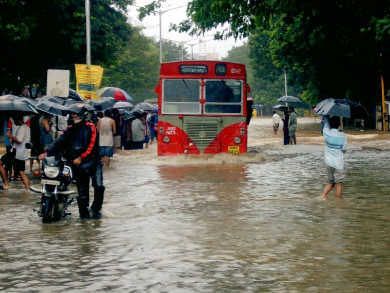
Photo: Inexplicable/Flickr
Key findings – hits and misses
The Chitale Committee, comprising seven experts besides the chairperson including noted civil engineer-planner Shirish Patel and environmental scientist at IIT-Bombay Dr Shyam Asolekar, focused on what went wrong on July 26-27, 2005, and how Mumbai can deal with massive floods. Its scope of work included analysing the factors responsible for the flood, evaluating the deficiencies and limitations of the storm water and sewage disposal systems, studying Mumbai’s rivers to understand the ineffective routing of natural flow, and suggesting guiding principles for the short and long-term.
The report is a compelling read about the city’s systems in a crisis. Committee members, individually and collectively, made site visits to the flooded areas, sought representations from agencies, heard experts and so on. Their observations in each section of the report and 20 recommendations at the end were a prescription for the battered city in 2005-2006.
Its key findings were that Mumbai’s rivers Mithi, Oshiwara, Dahisar, and Poisar had become dirty nullahs as they made their way to the Arabian Sea, streams like Mahul (which the report said should be a river) had completely disappeared from the city’s development planning, and Mithi had been diverted for various projects (like the airport) without thought to adverse consequences. The report took from earlier committees on flood mitigation; the Natu Committee (1975) and BRIMSTOWAD report (1993) which had recommended de-clogging natural streams and clearing encroachments to allow rainwater to flow uninterrupted into the Arabian Sea.[2]
Some recommendations were obvious such as streamlining communication systems which failed spectacularly on that day and rationalising the command-and-control mechanism of various agencies given that the first few hours of the July 2005 flood saw a mad scramble which led to upgrading the city’s disaster management protocols. The modernised Disaster Management Authority has been housed in a massive control room in the BMC supported by units in Mumbai’s 24 civic wards. The suggestion on rainfall recording and flood warning system – which had failed miserably on July 26, 2005 – resulted in better and more rain gauges.
Some recommendations like setting up a Mumbai Watershed Council – to comprehensively manage all of Mumbai’s water bodies – have not been implemented. Others were or are in various stages of consideration but without visible outcomes. However, all the flood risk zones of Mumbai have not been mapped and a 15-metre buffer zone (though minimum) along river banks has not been completed, as the Supreme Court-appointed committee pointed out in 2018-19.
“Many crucial measures either did not start or are slow-paced. Building pumping stations in Mahul and Mogra has been delayed for years. The Mithi River Development Project is a failure. Authorities have not been able to stop development in the waterlogging-prone areas,” pointed out RTI activist Anil Galgali following the issue. Added social activist Godfrey Pimenta, “even contour mapping has not been done afresh, Mumbai still uses 100-year-old maps for stormwater drains”.
The Chitale committee went into detail on each of Mumbai’s rivers, impediments in them and their role in stormwater management, listing the areas through which they flow, major and minor nullahs joining them, total catchment area, potential risk zones of each, “urban practices” such as construction which have changed flows, what happened on July 26-27, 2005, and the local losses. The report offered a comprehensive picture of each river, even suggesting that the Mahul outflow be seen as a river.
Have the authorities undertaken the work recommended? Even they will hesitate to affirm so. A MMRDA official told Question of Cities, “we only fund the projects for the Mithi river, the BMC does all the work” kicking the responsibility down the road.However, most recommendations, even if valid, are in urgent need of a review from the rainfall records of past few years, and a clear-eyed revision to suit the present climate change conditions.
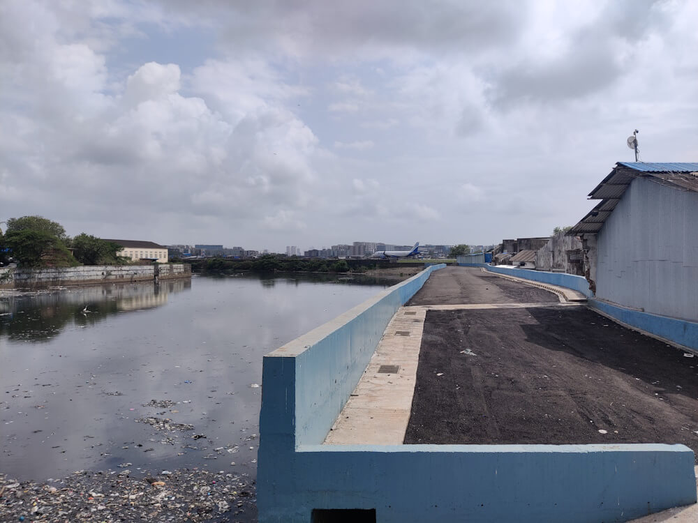
Photo: Jashvitha Dhagey
Ecology for flood management only
The report’s focus on ecology is in a chapter (number 7) titled “Environmental Management of Mumbai’s river basins” but its observations were limited largely to river systems, without the context of climate change, and somewhat contradictory in places. The guidelines do not call for specific changes in Mumbai’s Development Plans and reservations along the edges of the rivers. It skirts around the topic of holistic ecological restoration.
The report places rivers at the core of Mumbai’s “aquatic systems” which also include coastal zones and mangroves; for each river, it lists dense vegetation areas, spare areas, and forest areas besides the habited ones. Mumbai has “undergone a series of reclamations and transformations. Mere restoration of watercourses and water bodies will not provide the needed flood protection. We certainly need higher capacity of carrying floodwater and wastewater in our rivers and creeks but the inflow itself needs to be regulated through environmental upscaling and upgradation so that future floods can be handled with the help of appropriate engineering interventions in conjunction with the improvement of waste processing ability in the riparian zones, river beds and creeks,” the report noted but asked “is it possible, and more importantly practical, to restore Mumbai to say pre-1950 status?” Is there an alternative to ecological restoration, is the question to ask now.
The report listed ten sub-systems in Mumbai’s ecosystem: Mithi, Dahisar, Poisar and Oshiwara rivers, Powai Lake, Sanjay Gandhi National Park including Tulsi and Vihar lakes inside it, creeks, bays, estuary of Mithi, and coastal zones. Acknowledging that these have been strained by development, encroachments, debris dumping and pinching of rivers, and having questioned if restoration was practically possible, it suggests that the ecology of these need attention from the flood management perspective.
This is a limited view. Also, questioning if Mumbai’s ecology can be restored offered an escape for the agencies in charge to not even work towards it, as noted in the affidavits by MMRDA and BMC submitted to the Supreme Court. The report lists coastal zones and the mangrove ecosystem, explains ecosystem services, and charts out a framework for addressing the city’s environmental challenges in urban management – from the flood perspective. Instead of seeing the entire ecosystem only from the perspective of flood management, could the committee not have gone a step further for ecology itself? Now, the responsibility lies with the MMRDA and BMC to expand the scope but they are content to tick off the boxes on the recommendations made back then.
On the river ecosystems, the committee identified four risk zones: areas prone to wave action, naturally low-lying areas prone to submergence, riverbank areas prone to flooding, and chronic congestion sites. It recommended a distinct management plan for each category, drawn up in consultation with local residents, and drew the attention to “urban activities responsible for environmental degradation” – only for flood management. The Mithi gets enormous attention and space, rightly so. The report took a dim view of the bends in the river made for the Mumbai airport.
Mumbai’s environmentalists have pointed out that the Chitale Committee ignored the comprehensive ecological/environmental angle. “It talks about building embankments and concretising. The impact this would have on mangroves was not even thought of. Building an embankment means the creek water will stop flowing into the mangrove, destroying them,” said Debi Goenka, founder of Conservation Action Fund. “We have to protect the natural drainage and natural assets, salt pans or mangroves to stop extreme climatic events.”
Photo: Shishirdasika/Wikimedia Commons
For Mumbai’s sustainable future?
In the “Framework for addressing Environmental Challenges” (section 7.4), the report acknowledged that sustainable development is key to people’s lives but limits this to managing “Mumbai’s aquatic systems”. It also made people’s empowerment a key factor though people of Mumbai hardly have a say in planning or implementation. The report also spoke of the “polluter pays principle” and “precautionary principle”, recommending that the future use of dense vegetation and forest areas of each river will have to be carefully planned and “the immediate hydraulic safety of riverine areas” should be ensured. But it does not lay down how to achieve this nor was this made incumbent on the BMC and MMRDA. As a result, Mumbai’s development over the past two decades has chipped away riverine areas.
Importantly, the report does not see ecological setbacks in land reclamation, use of salt pan lands, and relaxing CRZ norms. It acknowledges that “reclamation due to construction along the coasts, in wetlands, creeks and mudflats has aggravated the risk of flooding” naming Bhakti Park and IMAX in Wadala in the catchment area of Mahul but concludes (in 9.14.1) “reclamation has become a dirty word…reclamation from the sea, per se, does not damage the environment. It needs to be undertaken, if required or considered desirable, with proper attendant hydraulic model studies”.
In (9.14.3), the report states: “Land used as salt pans is well located…The pressing demand is for such land to be used for low- and middle-income housing. There is a clear case here for change of land use”. On CRZ, it states: “The law achieves very little beyond removing perfectly viable land for housing from the possibility of development…this is not to say that we should not preserve Mumbai’s beaches, mangroves and ecologically-sensitive areas but it need not be mindlessly done as the CRZ law prescribes”. The report calls for protecting and increasing tree cover but as part of flood management.
These observations have allowed the authorities to carry on business-as-usual in the past few years despite the climate impact, including unbridled construction in ecologically-sensitive zones.
The committee did recommend cautious use of FSI as a tool of development. Of its 20 recommendations, eight pertain directly to environmental aspects. Most of the eight are about restoring the ecosystems of rivers, rejuvenation of lakes, ponds and hill slopes, and coastal areas, renewing the mangrove ecosystem, and protecting the Sanjay Gandhi National Park besides auditing environmental-related activities, levying “environmental cess” to sustain such services. It suggested “watershed-based” development planning, a welcome move, but suggested quantification of ecosystem services in commercial markets which could turn hazardous.
If the focus was on restoring the city’s ecology, it would, when restored and renewed, naturally take care of flood management. This perspective must guide a review of the Chitale Committee recommendations now.
Shobha Surin, currently based in Bhubaneswar, is a journalist with 20 years of experience in newsrooms in Mumbai. An Associate Editor at Question of Cities, she is concerned about Climate Change and is learning about sustainable development.
Cover photo: Creative Commons